You are here: Home > Network List > TX - Texas Seismological Network Stations List
> Station WTFS Witchita Falls > Earthquake Result Viewer
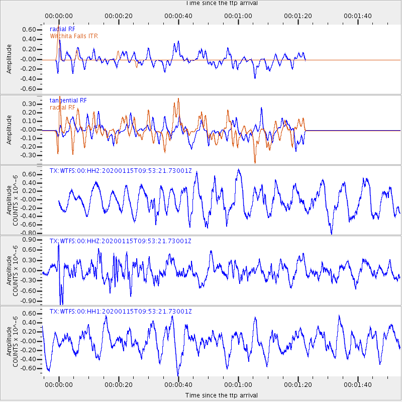
WTFS Witchita Falls - Earthquake Result Viewer
*The percent match for this event was below the threshold and hence no stack was calculated.
| Earthquake location: |
Near Coast Of Peru |
| Earthquake latitude/longitude: |
-10.4/-78.6 |
| Earthquake time(UTC): |
2020/01/15 (015) 09:45:18 GMT |
| Earthquake Depth: |
38 km |
| Earthquake Magnitude: |
5.4 Mww |
| Earthquake Catalog/Contributor: |
NEIC PDE/us |
|
| Network: |
TX Texas Seismological Network |
| Station: |
WTFS Witchita Falls |
| Lat/Lon: |
33.77 N/98.46 W |
| Elevation: |
277 m |
|
| Distance: |
47.8 deg |
| Az: |
337.527 deg |
| Baz: |
153.162 deg |
| Ray Param: |
$rayparam |
*The percent match for this event was below the threshold and hence was not used in the summary stack. |
|
| Radial Match: |
49.468117 % |
| Radial Bump: |
353 |
| Transverse Match: |
32.105022 % |
| Transverse Bump: |
275 |
| SOD ConfigId: |
20465011 |
| Insert Time: |
2020-02-12 09:32:17.525 +0000 |
| GWidth: |
2.5 |
| Max Bumps: |
400 |
| Tol: |
0.001 |
|
Signal To Noise
| Channel | StoN | STA | LTA |
| TX:WTFS:00:HHZ:20200115T09:53:21.73001Z | 3.01505 | 4.0759303E-7 | 1.3518617E-7 |
| TX:WTFS:00:HH1:20200115T09:53:21.73001Z | 0.37725574 | 9.362681E-8 | 2.4817862E-7 |
| TX:WTFS:00:HH2:20200115T09:53:21.73001Z | 1.1457214 | 2.413329E-7 | 2.1063838E-7 |
| Arrivals |
| Ps | |
| PpPs | |
| PsPs/PpSs | |


