You are here: Home > Network List > TS - TERRAscope (Southern California Seismic Network) Stations List
> Station PFO Pinon Flat, California, USA > Earthquake Result Viewer
PFO Pinon Flat, California, USA - Earthquake Result Viewer
| Earthquake location: |
Near Coast Of Central Chile |
| Earthquake latitude/longitude: |
-31.4/-71.9 |
| Earthquake time(UTC): |
1992/11/28 (333) 03:13:37 GMT |
| Earthquake Depth: |
39 km |
| Earthquake Magnitude: |
5.9 MB, 6.4 MS, 6.0 MD |
| Earthquake Catalog/Contributor: |
WHDF/NEIC |
|
| Network: |
TS TERRAscope (Southern California Seismic Network) |
| Station: |
PFO Pinon Flat, California, USA |
| Lat/Lon: |
33.61 N/116.46 W |
| Elevation: |
1280 m |
|
| Distance: |
77.1 deg |
| Az: |
323.115 deg |
| Baz: |
142.046 deg |
| Ray Param: |
0.050492164 |
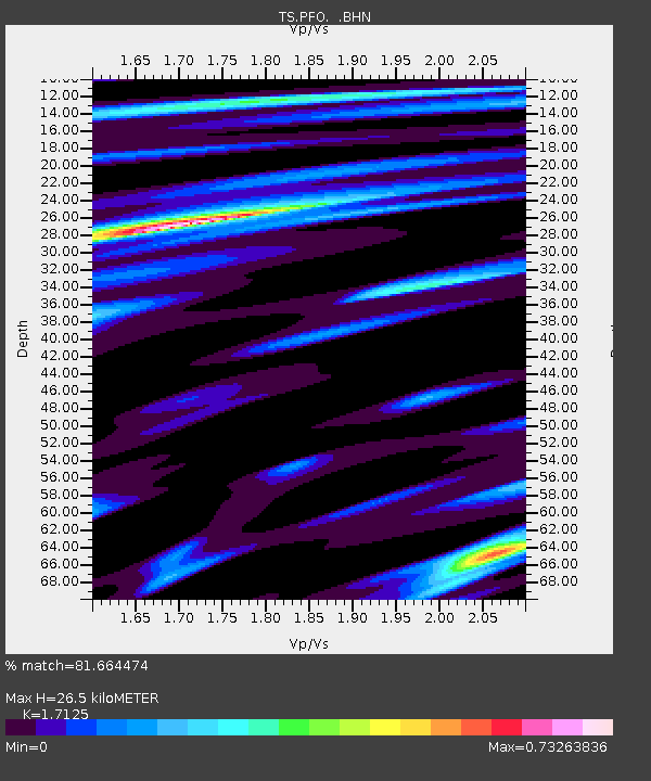
| Estimated Moho Depth: |
26.5 km |
| Estimated Crust Vp/Vs: |
1.71 |
| Assumed Crust Vp: |
6.264 km/s |
| Estimated Crust Vs: |
3.658 km/s |
| Estimated Crust Poisson's Ratio: |
0.24 |
|
| Radial Match: |
81.664474 % |
| Radial Bump: |
400 |
| Transverse Match: |
85.16888 % |
| Transverse Bump: |
400 |
| SOD ConfigId: |
16938 |
| Insert Time: |
2010-02-26 14:41:57.281 +0000 |
| GWidth: |
2.5 |
| Max Bumps: |
400 |
| Tol: |
0.001 |
|
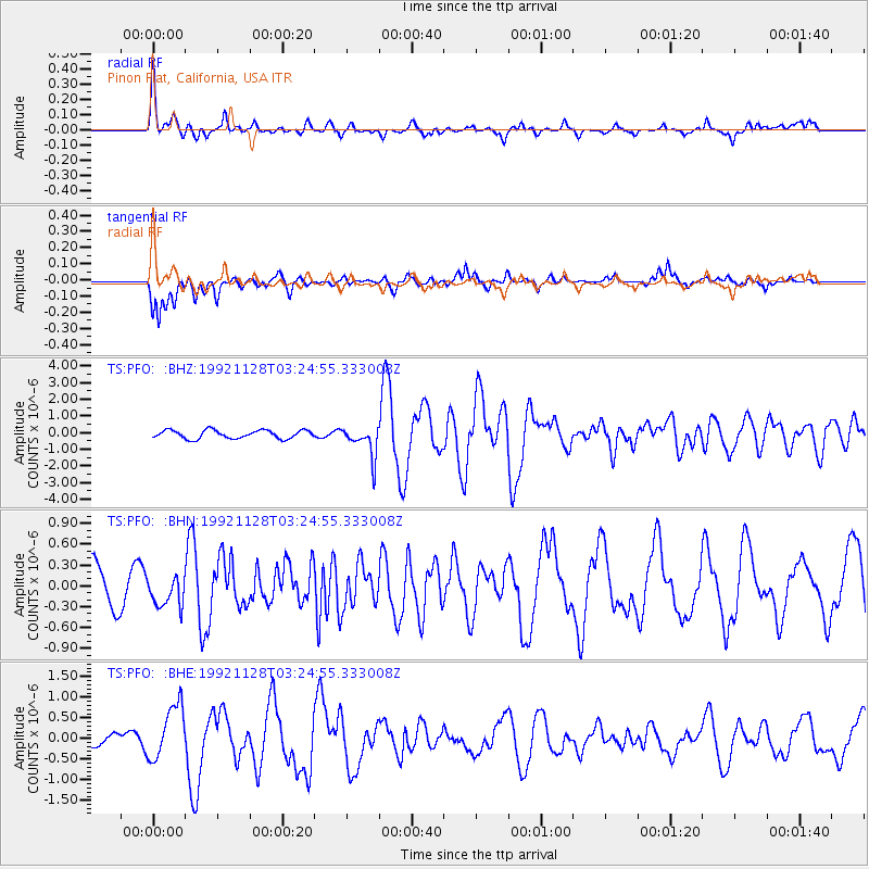
Signal To Noise
| Channel | StoN | STA | LTA |
| TS:PFO: :BHN:19921128T03:24:55.333008Z | 0.87334865 | 2.1847507E-7 | 2.501579E-7 |
| TS:PFO: :BHE:19921128T03:24:55.333008Z | 3.5326076 | 6.5776453E-7 | 1.8619801E-7 |
| TS:PFO: :BHZ:19921128T03:24:55.333008Z | 3.706937 | 9.364301E-7 | 2.526156E-7 |
| Arrivals |
| Ps | 3.1 SECOND |
| PpPs | 11 SECOND |
| PsPs/PpSs | 14 SECOND |


