You are here: Home > Network List > TS - TERRAscope (Southern California Seismic Network) Stations List
> Station PFO Pinon Flat, California, USA > Earthquake Result Viewer
PFO Pinon Flat, California, USA - Earthquake Result Viewer

| Earthquake location: |
Hokkaido, Japan Region |
| Earthquake latitude/longitude: |
41.4/142.1 |
| Earthquake time(UTC): |
1992/07/12 (194) 11:08:56 GMT |
| Earthquake Depth: |
70 km |
| Earthquake Magnitude: |
5.9 MB |
| Earthquake Catalog/Contributor: |
WHDF/NEIC |
|
| Network: |
TS TERRAscope (Southern California Seismic Network) |
| Station: |
PFO Pinon Flat, California, USA |
| Lat/Lon: |
33.61 N/116.46 W |
| Elevation: |
1280 m |
|
| Distance: |
76.2 deg |
| Az: |
57.358 deg |
| Baz: |
310.66 deg |
| Ray Param: |
0.050995544 |
| Estimated Moho Depth: |
29.75 km |
| Estimated Crust Vp/Vs: |
1.74 |
| Assumed Crust Vp: |
6.264 km/s |
| Estimated Crust Vs: |
3.61 km/s |
| Estimated Crust Poisson's Ratio: |
0.25 |
|
| Radial Match: |
93.49075 % |
| Radial Bump: |
326 |
| Transverse Match: |
89.15592 % |
| Transverse Bump: |
374 |
| SOD ConfigId: |
17000 |
| Insert Time: |
2010-02-26 14:41:59.487 +0000 |
| GWidth: |
2.5 |
| Max Bumps: |
400 |
| Tol: |
0.001 |
|
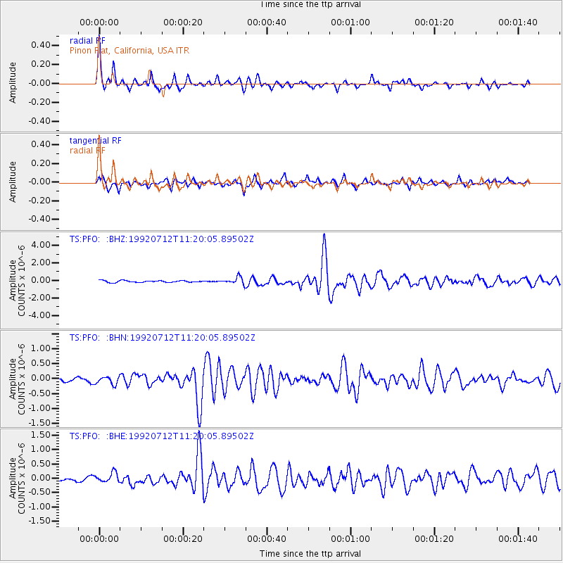
Signal To Noise
| Channel | StoN | STA | LTA |
| TS:PFO: :BHN:19920712T11:20:05.89502Z | 1.7518114 | 1.269458E-7 | 7.2465454E-8 |
| TS:PFO: :BHE:19920712T11:20:05.89502Z | 3.190005 | 1.9106926E-7 | 5.989623E-8 |
| TS:PFO: :BHZ:19920712T11:20:05.89502Z | 3.9533174 | 4.0618283E-7 | 1.02744806E-7 |
| Arrivals |
| Ps | 3.6 SECOND |
| PpPs | 13 SECOND |
| PsPs/PpSs | 16 SECOND |


