You are here: Home > Network List > CI - Caltech Regional Seismic Network Stations List
> Station GLA Glamis, Glamis, CA, USA > Earthquake Result Viewer
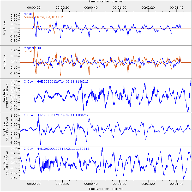
GLA Glamis, Glamis, CA, USA - Earthquake Result Viewer
*The percent match for this event was below the threshold and hence no stack was calculated.
| Earthquake location: |
Solomon Islands |
| Earthquake latitude/longitude: |
-10.4/161.3 |
| Earthquake time(UTC): |
2020/01/29 (029) 13:49:50 GMT |
| Earthquake Depth: |
87 km |
| Earthquake Magnitude: |
6.0 Mww |
| Earthquake Catalog/Contributor: |
NEIC PDE/us |
|
| Network: |
CI Caltech Regional Seismic Network |
| Station: |
GLA Glamis, Glamis, CA, USA |
| Lat/Lon: |
33.05 N/114.83 W |
| Elevation: |
610 m |
|
| Distance: |
90.5 deg |
| Az: |
56.628 deg |
| Baz: |
258.048 deg |
| Ray Param: |
$rayparam |
*The percent match for this event was below the threshold and hence was not used in the summary stack. |
|
| Radial Match: |
61.286453 % |
| Radial Bump: |
400 |
| Transverse Match: |
58.057262 % |
| Transverse Bump: |
400 |
| SOD ConfigId: |
20465011 |
| Insert Time: |
2020-02-12 13:55:19.795 +0000 |
| GWidth: |
2.5 |
| Max Bumps: |
400 |
| Tol: |
0.001 |
|
Signal To Noise
| Channel | StoN | STA | LTA |
| CI:GLA: :HHZ:20200129T14:02:11.118021Z | 2.9444914 | 7.1791E-7 | 2.4381458E-7 |
| CI:GLA: :HHN:20200129T14:02:11.118021Z | 1.7847996 | 2.508803E-7 | 1.4056498E-7 |
| CI:GLA: :HHE:20200129T14:02:11.118021Z | 2.5293148 | 4.0420244E-7 | 1.5980709E-7 |
| Arrivals |
| Ps | |
| PpPs | |
| PsPs/PpSs | |


