You are here: Home > Network List > TS - TERRAscope (Southern California Seismic Network) Stations List
> Station PFO Pinon Flat, California, USA > Earthquake Result Viewer
PFO Pinon Flat, California, USA - Earthquake Result Viewer
| Earthquake location: |
Santa Cruz Islands |
| Earthquake latitude/longitude: |
-12.0/166.5 |
| Earthquake time(UTC): |
1992/08/04 (217) 21:08:44 GMT |
| Earthquake Depth: |
109 km |
| Earthquake Magnitude: |
5.9 MB |
| Earthquake Catalog/Contributor: |
WHDF/NEIC |
|
| Network: |
TS TERRAscope (Southern California Seismic Network) |
| Station: |
PFO Pinon Flat, California, USA |
| Lat/Lon: |
33.61 N/116.46 W |
| Elevation: |
1280 m |
|
| Distance: |
86.0 deg |
| Az: |
54.612 deg |
| Baz: |
252.889 deg |
| Ray Param: |
0.044100888 |
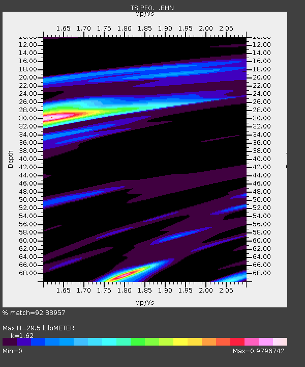
| Estimated Moho Depth: |
29.5 km |
| Estimated Crust Vp/Vs: |
1.62 |
| Assumed Crust Vp: |
6.264 km/s |
| Estimated Crust Vs: |
3.866 km/s |
| Estimated Crust Poisson's Ratio: |
0.19 |
|
| Radial Match: |
92.88957 % |
| Radial Bump: |
400 |
| Transverse Match: |
84.23807 % |
| Transverse Bump: |
400 |
| SOD ConfigId: |
17000 |
| Insert Time: |
2010-02-26 14:42:02.384 +0000 |
| GWidth: |
2.5 |
| Max Bumps: |
400 |
| Tol: |
0.001 |
|
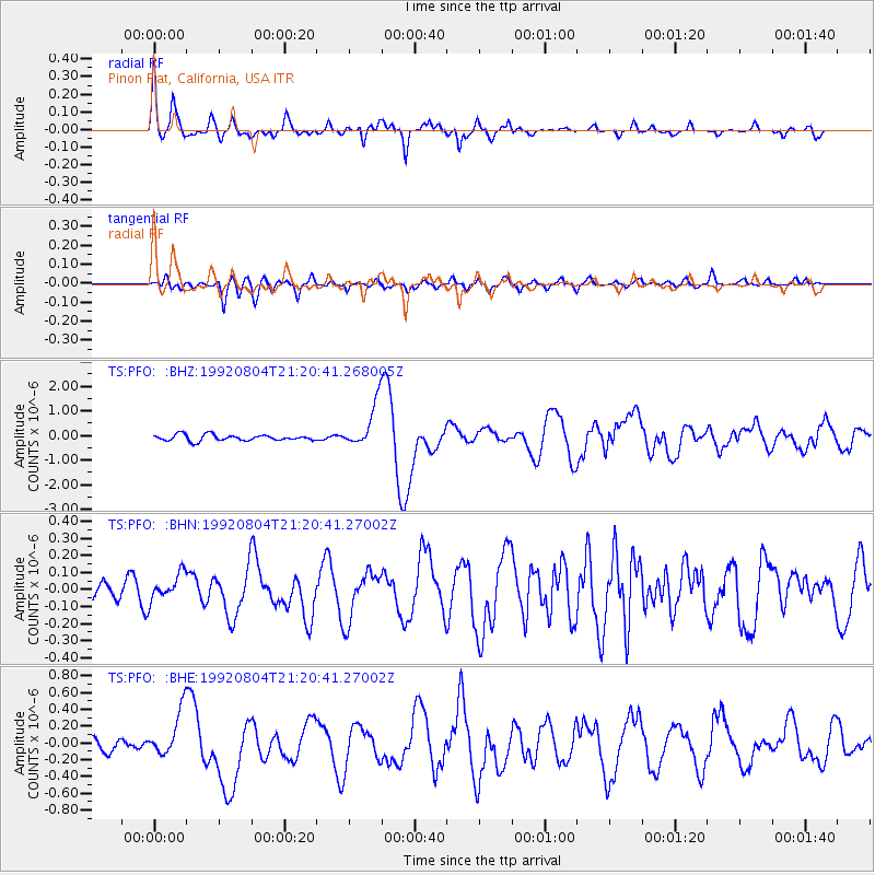
Signal To Noise
| Channel | StoN | STA | LTA |
| TS:PFO: :BHN:19920804T21:20:41.27002Z | 1.7405882 | 8.115956E-8 | 4.662767E-8 |
| TS:PFO: :BHE:19920804T21:20:41.27002Z | 2.5071702 | 2.7979053E-7 | 1.1159615E-7 |
| TS:PFO: :BHZ:19920804T21:20:41.268005Z | 7.6186266 | 9.1085445E-7 | 1.1955625E-7 |
| Arrivals |
| Ps | 3.0 SECOND |
| PpPs | 12 SECOND |
| PsPs/PpSs | 15 SECOND |


