You are here: Home > Network List > TS - TERRAscope (Southern California Seismic Network) Stations List
> Station PFO Pinon Flat, California, USA > Earthquake Result Viewer
PFO Pinon Flat, California, USA - Earthquake Result Viewer
| Earthquake location: |
Fiji Islands Region |
| Earthquake latitude/longitude: |
-17.7/-178.8 |
| Earthquake time(UTC): |
1992/08/30 (243) 20:09:06 GMT |
| Earthquake Depth: |
573 km |
| Earthquake Magnitude: |
5.8 MB |
| Earthquake Catalog/Contributor: |
WHDF/NEIC |
|
| Network: |
TS TERRAscope (Southern California Seismic Network) |
| Station: |
PFO Pinon Flat, California, USA |
| Lat/Lon: |
33.61 N/116.46 W |
| Elevation: |
1280 m |
|
| Distance: |
78.3 deg |
| Az: |
48.998 deg |
| Baz: |
239.526 deg |
| Ray Param: |
0.047955275 |
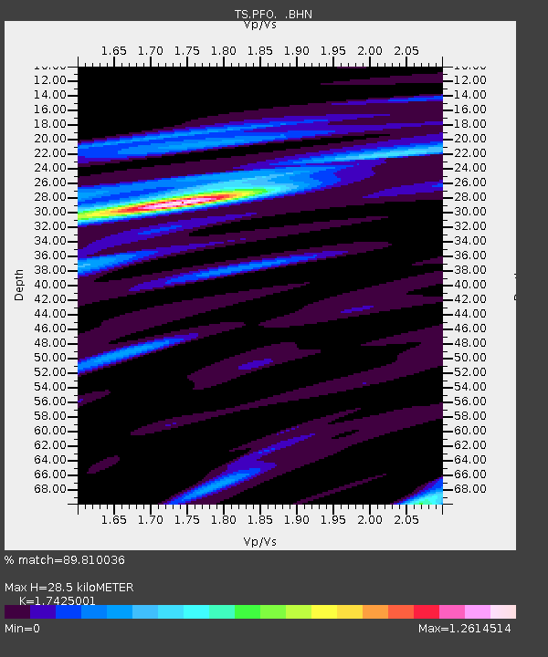
| Estimated Moho Depth: |
28.5 km |
| Estimated Crust Vp/Vs: |
1.74 |
| Assumed Crust Vp: |
6.264 km/s |
| Estimated Crust Vs: |
3.595 km/s |
| Estimated Crust Poisson's Ratio: |
0.25 |
|
| Radial Match: |
89.810036 % |
| Radial Bump: |
400 |
| Transverse Match: |
80.54186 % |
| Transverse Bump: |
400 |
| SOD ConfigId: |
17000 |
| Insert Time: |
2010-02-26 14:42:03.557 +0000 |
| GWidth: |
2.5 |
| Max Bumps: |
400 |
| Tol: |
0.001 |
|
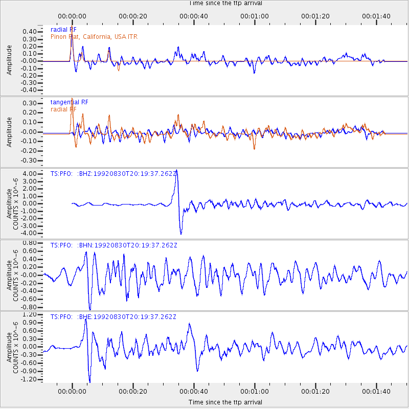
Signal To Noise
| Channel | StoN | STA | LTA |
| TS:PFO: :BHN:19920830T20:19:37.262Z | 4.6339025 | 2.693253E-7 | 5.8120627E-8 |
| TS:PFO: :BHE:19920830T20:19:37.262Z | 4.2531157 | 3.9634028E-7 | 9.318822E-8 |
| TS:PFO: :BHZ:19920830T20:19:37.262Z | 16.809591 | 1.7830288E-6 | 1.06072115E-7 |
| Arrivals |
| Ps | 3.5 SECOND |
| PpPs | 12 SECOND |
| PsPs/PpSs | 16 SECOND |


