You are here: Home > Network List > TA - USArray Transportable Network (new EarthScope stations) Stations List
> Station A22K Sinclair Lake, AK, USA > Earthquake Result Viewer
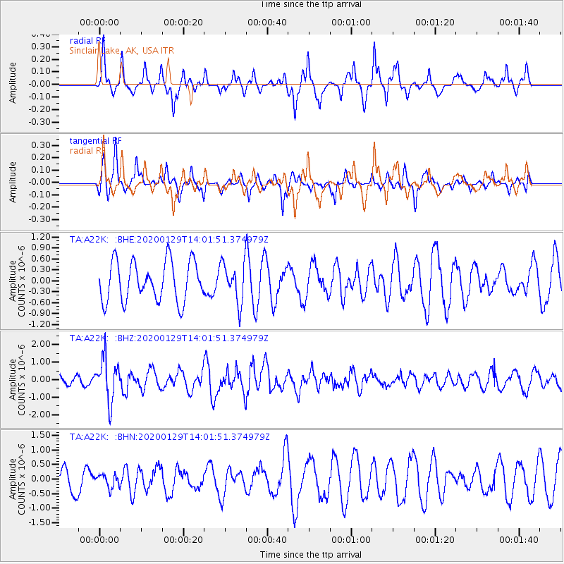
A22K Sinclair Lake, AK, USA - Earthquake Result Viewer
*The percent match for this event was below the threshold and hence no stack was calculated.
| Earthquake location: |
Solomon Islands |
| Earthquake latitude/longitude: |
-10.4/161.3 |
| Earthquake time(UTC): |
2020/01/29 (029) 13:49:50 GMT |
| Earthquake Depth: |
87 km |
| Earthquake Magnitude: |
6.0 Mww |
| Earthquake Catalog/Contributor: |
NEIC PDE/us |
|
| Network: |
TA USArray Transportable Network (new EarthScope stations) |
| Station: |
A22K Sinclair Lake, AK, USA |
| Lat/Lon: |
71.00 N/154.97 W |
| Elevation: |
6.0 m |
|
| Distance: |
86.3 deg |
| Az: |
13.114 deg |
| Baz: |
222.975 deg |
| Ray Param: |
$rayparam |
*The percent match for this event was below the threshold and hence was not used in the summary stack. |
|
| Radial Match: |
72.16144 % |
| Radial Bump: |
292 |
| Transverse Match: |
64.61046 % |
| Transverse Bump: |
321 |
| SOD ConfigId: |
20465011 |
| Insert Time: |
2020-02-12 14:00:34.777 +0000 |
| GWidth: |
2.5 |
| Max Bumps: |
400 |
| Tol: |
0.001 |
|
Signal To Noise
| Channel | StoN | STA | LTA |
| TA:A22K: :BHZ:20200129T14:01:51.374979Z | 4.2840576 | 1.2158739E-6 | 2.8381365E-7 |
| TA:A22K: :BHN:20200129T14:01:51.374979Z | 0.48275775 | 2.2482374E-7 | 4.6570716E-7 |
| TA:A22K: :BHE:20200129T14:01:51.374979Z | 1.0129629 | 5.503146E-7 | 5.4327217E-7 |
| Arrivals |
| Ps | |
| PpPs | |
| PsPs/PpSs | |


