You are here: Home > Network List > TA - USArray Transportable Network (new EarthScope stations) Stations List
> Station C16K Lisburne Hills, AK, USA > Earthquake Result Viewer
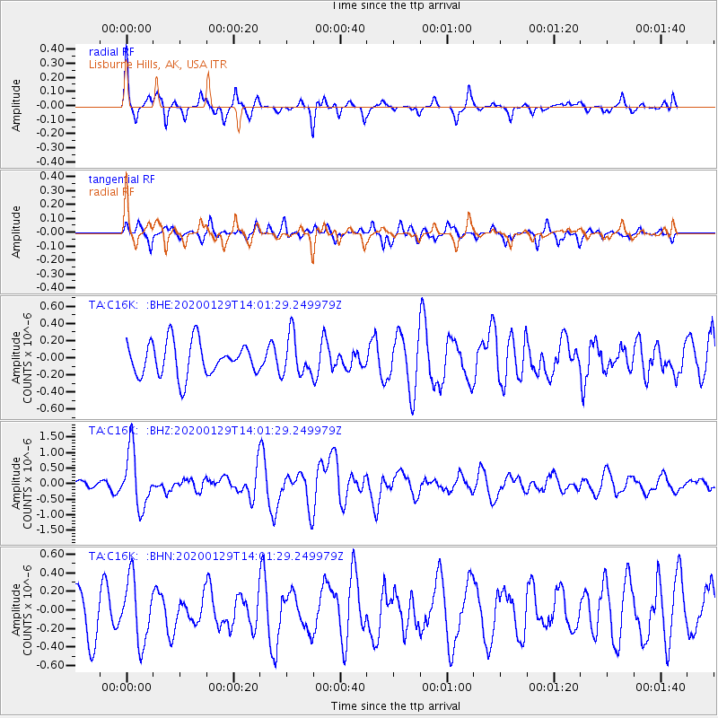
C16K Lisburne Hills, AK, USA - Earthquake Result Viewer
*The percent match for this event was below the threshold and hence no stack was calculated.
| Earthquake location: |
Solomon Islands |
| Earthquake latitude/longitude: |
-10.4/161.3 |
| Earthquake time(UTC): |
2020/01/29 (029) 13:49:50 GMT |
| Earthquake Depth: |
87 km |
| Earthquake Magnitude: |
6.0 Mww |
| Earthquake Catalog/Contributor: |
NEIC PDE/us |
|
| Network: |
TA USArray Transportable Network (new EarthScope stations) |
| Station: |
C16K Lisburne Hills, AK, USA |
| Lat/Lon: |
68.27 N/165.34 W |
| Elevation: |
102 m |
|
| Distance: |
82.0 deg |
| Az: |
11.938 deg |
| Baz: |
213.136 deg |
| Ray Param: |
$rayparam |
*The percent match for this event was below the threshold and hence was not used in the summary stack. |
|
| Radial Match: |
68.963554 % |
| Radial Bump: |
275 |
| Transverse Match: |
54.915085 % |
| Transverse Bump: |
353 |
| SOD ConfigId: |
20465011 |
| Insert Time: |
2020-02-12 14:00:38.097 +0000 |
| GWidth: |
2.5 |
| Max Bumps: |
400 |
| Tol: |
0.001 |
|
Signal To Noise
| Channel | StoN | STA | LTA |
| TA:C16K: :BHZ:20200129T14:01:29.249979Z | 4.85233 | 9.1153976E-7 | 1.8785609E-7 |
| TA:C16K: :BHN:20200129T14:01:29.249979Z | 1.9320407 | 3.4139606E-7 | 1.7670232E-7 |
| TA:C16K: :BHE:20200129T14:01:29.249979Z | 1.1961527 | 2.3253102E-7 | 1.943991E-7 |
| Arrivals |
| Ps | |
| PpPs | |
| PsPs/PpSs | |


