You are here: Home > Network List > TA - USArray Transportable Network (new EarthScope stations) Stations List
> Station D23K Nanushuk River, AK USA > Earthquake Result Viewer
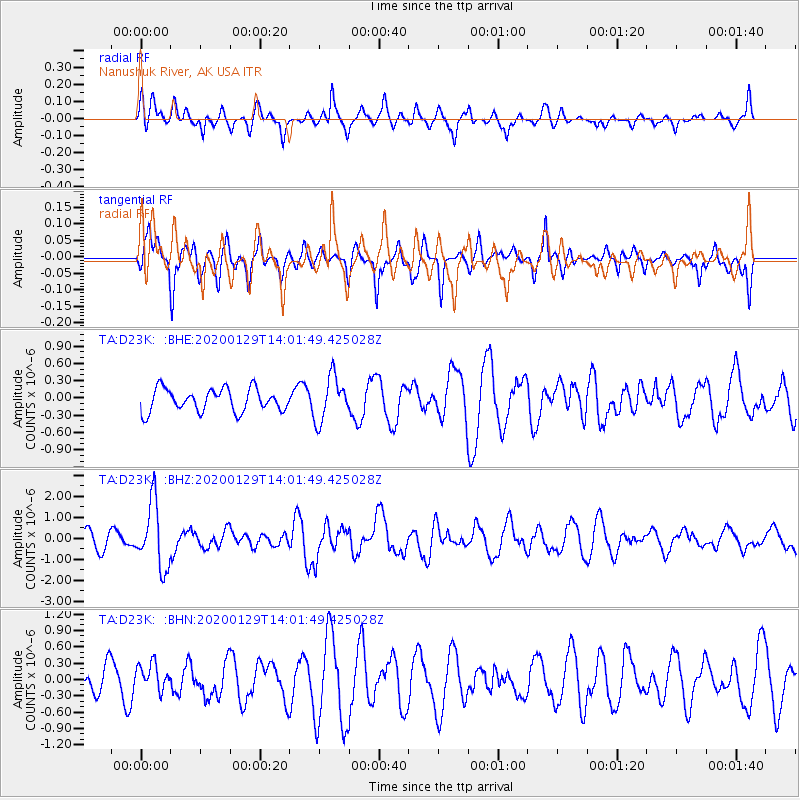
D23K Nanushuk River, AK USA - Earthquake Result Viewer
*The percent match for this event was below the threshold and hence no stack was calculated.
| Earthquake location: |
Solomon Islands |
| Earthquake latitude/longitude: |
-10.4/161.3 |
| Earthquake time(UTC): |
2020/01/29 (029) 13:49:50 GMT |
| Earthquake Depth: |
87 km |
| Earthquake Magnitude: |
6.0 Mww |
| Earthquake Catalog/Contributor: |
NEIC PDE/us |
|
| Network: |
TA USArray Transportable Network (new EarthScope stations) |
| Station: |
D23K Nanushuk River, AK USA |
| Lat/Lon: |
68.97 N/150.68 W |
| Elevation: |
406 m |
|
| Distance: |
85.9 deg |
| Az: |
15.613 deg |
| Baz: |
227.175 deg |
| Ray Param: |
$rayparam |
*The percent match for this event was below the threshold and hence was not used in the summary stack. |
|
| Radial Match: |
60.8553 % |
| Radial Bump: |
348 |
| Transverse Match: |
63.727066 % |
| Transverse Bump: |
362 |
| SOD ConfigId: |
20465011 |
| Insert Time: |
2020-02-12 14:00:54.295 +0000 |
| GWidth: |
2.5 |
| Max Bumps: |
400 |
| Tol: |
0.001 |
|
Signal To Noise
| Channel | StoN | STA | LTA |
| TA:D23K: :BHZ:20200129T14:01:49.425028Z | 2.797229 | 1.554853E-6 | 5.5585474E-7 |
| TA:D23K: :BHN:20200129T14:01:49.425028Z | 0.64083385 | 2.4683777E-7 | 3.8518218E-7 |
| TA:D23K: :BHE:20200129T14:01:49.425028Z | 1.9511244 | 3.8490316E-7 | 1.9727248E-7 |
| Arrivals |
| Ps | |
| PpPs | |
| PsPs/PpSs | |


