You are here: Home > Network List > TA - USArray Transportable Network (new EarthScope stations) Stations List
> Station F21K Alatna River, AK, USA > Earthquake Result Viewer
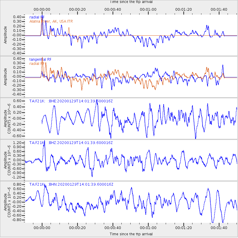
F21K Alatna River, AK, USA - Earthquake Result Viewer
*The percent match for this event was below the threshold and hence no stack was calculated.
| Earthquake location: |
Solomon Islands |
| Earthquake latitude/longitude: |
-10.4/161.3 |
| Earthquake time(UTC): |
2020/01/29 (029) 13:49:50 GMT |
| Earthquake Depth: |
87 km |
| Earthquake Magnitude: |
6.0 Mww |
| Earthquake Catalog/Contributor: |
NEIC PDE/us |
|
| Network: |
TA USArray Transportable Network (new EarthScope stations) |
| Station: |
F21K Alatna River, AK, USA |
| Lat/Lon: |
67.22 N/153.48 W |
| Elevation: |
597 m |
|
| Distance: |
84.0 deg |
| Az: |
16.141 deg |
| Baz: |
224.624 deg |
| Ray Param: |
$rayparam |
*The percent match for this event was below the threshold and hence was not used in the summary stack. |
|
| Radial Match: |
55.99152 % |
| Radial Bump: |
400 |
| Transverse Match: |
48.804203 % |
| Transverse Bump: |
397 |
| SOD ConfigId: |
20465011 |
| Insert Time: |
2020-02-12 14:01:19.357 +0000 |
| GWidth: |
2.5 |
| Max Bumps: |
400 |
| Tol: |
0.001 |
|
Signal To Noise
| Channel | StoN | STA | LTA |
| TA:F21K: :BHZ:20200129T14:01:39.600016Z | 3.6877167 | 6.0226205E-7 | 1.6331572E-7 |
| TA:F21K: :BHN:20200129T14:01:39.600016Z | 2.250325 | 4.677133E-7 | 2.0784256E-7 |
| TA:F21K: :BHE:20200129T14:01:39.600016Z | 1.5182829 | 3.2624567E-7 | 2.1487806E-7 |
| Arrivals |
| Ps | |
| PpPs | |
| PsPs/PpSs | |


