You are here: Home > Network List > TA - USArray Transportable Network (new EarthScope stations) Stations List
> Station O17K Koliganek, Bristol Bay, AK, USA > Earthquake Result Viewer
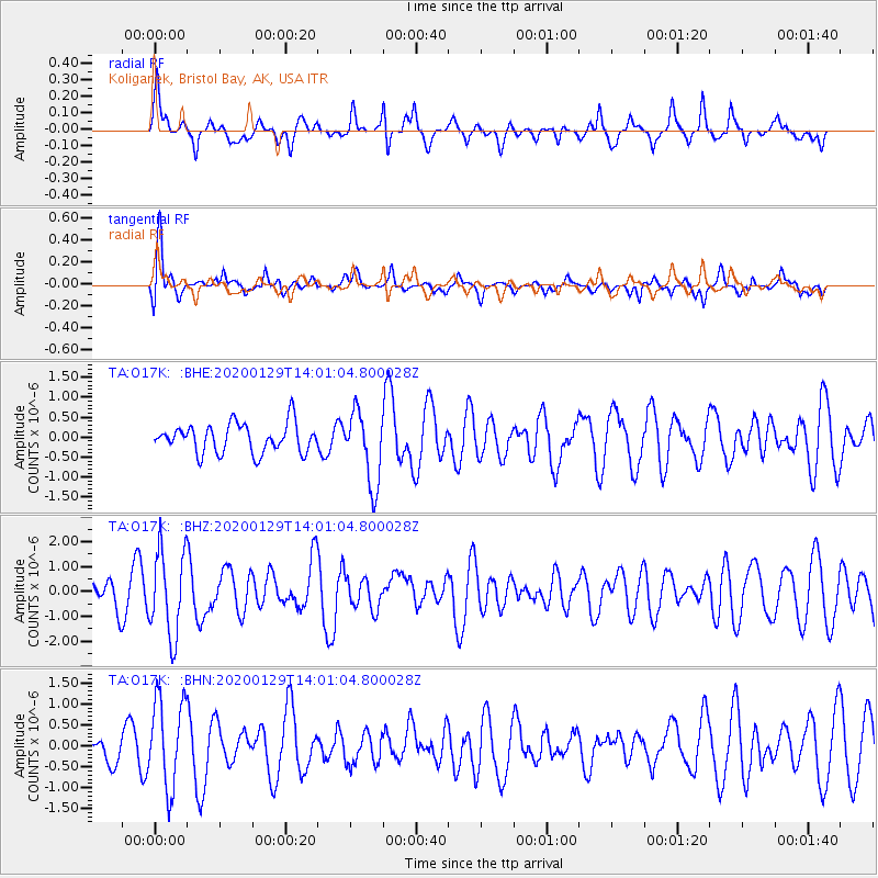
O17K Koliganek, Bristol Bay, AK, USA - Earthquake Result Viewer
*The percent match for this event was below the threshold and hence no stack was calculated.
| Earthquake location: |
Solomon Islands |
| Earthquake latitude/longitude: |
-10.4/161.3 |
| Earthquake time(UTC): |
2020/01/29 (029) 13:49:50 GMT |
| Earthquake Depth: |
87 km |
| Earthquake Magnitude: |
6.0 Mww |
| Earthquake Catalog/Contributor: |
NEIC PDE/us |
|
| Network: |
TA USArray Transportable Network (new EarthScope stations) |
| Station: |
O17K Koliganek, Bristol Bay, AK, USA |
| Lat/Lon: |
59.77 N/157.09 W |
| Elevation: |
156 m |
|
| Distance: |
77.4 deg |
| Az: |
20.142 deg |
| Baz: |
222.037 deg |
| Ray Param: |
$rayparam |
*The percent match for this event was below the threshold and hence was not used in the summary stack. |
|
| Radial Match: |
60.85686 % |
| Radial Bump: |
366 |
| Transverse Match: |
69.2133 % |
| Transverse Bump: |
400 |
| SOD ConfigId: |
20465011 |
| Insert Time: |
2020-02-12 14:02:25.848 +0000 |
| GWidth: |
2.5 |
| Max Bumps: |
400 |
| Tol: |
0.001 |
|
Signal To Noise
| Channel | StoN | STA | LTA |
| TA:O17K: :BHZ:20200129T14:01:04.800028Z | 3.913403 | 1.7086007E-6 | 4.3660228E-7 |
| TA:O17K: :BHN:20200129T14:01:04.800028Z | 1.2000343 | 1.0695841E-6 | 8.912946E-7 |
| TA:O17K: :BHE:20200129T14:01:04.800028Z | 2.505414 | 9.118014E-7 | 3.6393243E-7 |
| Arrivals |
| Ps | |
| PpPs | |
| PsPs/PpSs | |


