You are here: Home > Network List > US - United States National Seismic Network Stations List
> Station HAWA Hanford, Washington, USA > Earthquake Result Viewer
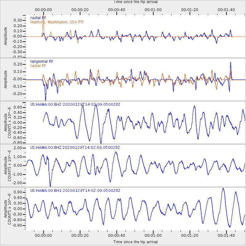
HAWA Hanford, Washington, USA - Earthquake Result Viewer
*The percent match for this event was below the threshold and hence no stack was calculated.
| Earthquake location: |
Solomon Islands |
| Earthquake latitude/longitude: |
-10.4/161.3 |
| Earthquake time(UTC): |
2020/01/29 (029) 13:49:50 GMT |
| Earthquake Depth: |
87 km |
| Earthquake Magnitude: |
6.0 Mww |
| Earthquake Catalog/Contributor: |
NEIC PDE/us |
|
| Network: |
US United States National Seismic Network |
| Station: |
HAWA Hanford, Washington, USA |
| Lat/Lon: |
46.39 N/119.53 W |
| Elevation: |
364 m |
|
| Distance: |
90.1 deg |
| Az: |
42.832 deg |
| Baz: |
255.104 deg |
| Ray Param: |
$rayparam |
*The percent match for this event was below the threshold and hence was not used in the summary stack. |
|
| Radial Match: |
55.539364 % |
| Radial Bump: |
400 |
| Transverse Match: |
68.96019 % |
| Transverse Bump: |
400 |
| SOD ConfigId: |
20465011 |
| Insert Time: |
2020-02-12 14:03:17.539 +0000 |
| GWidth: |
2.5 |
| Max Bumps: |
400 |
| Tol: |
0.001 |
|
Signal To Noise
| Channel | StoN | STA | LTA |
| US:HAWA:00:BHZ:20200129T14:02:09.050028Z | 3.028889 | 1.14269E-6 | 3.7726377E-7 |
| US:HAWA:00:BH1:20200129T14:02:09.050028Z | 1.0286256 | 3.4425847E-7 | 3.346781E-7 |
| US:HAWA:00:BH2:20200129T14:02:09.050028Z | 1.5752866 | 4.3356022E-7 | 2.7522623E-7 |
| Arrivals |
| Ps | |
| PpPs | |
| PsPs/PpSs | |


