You are here: Home > Network List > UW - Pacific Northwest Regional Seismic Network Stations List
> Station IRON Crane, OR, USA > Earthquake Result Viewer
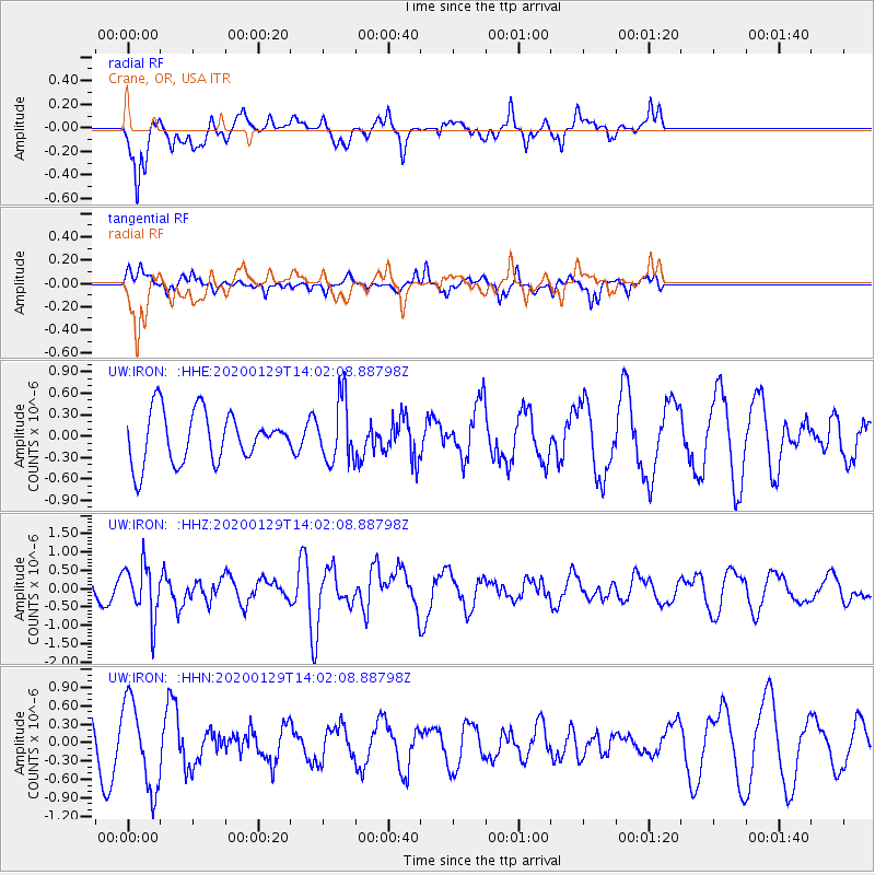
IRON Crane, OR, USA - Earthquake Result Viewer
*The percent match for this event was below the threshold and hence no stack was calculated.
| Earthquake location: |
Solomon Islands |
| Earthquake latitude/longitude: |
-10.4/161.3 |
| Earthquake time(UTC): |
2020/01/29 (029) 13:49:50 GMT |
| Earthquake Depth: |
87 km |
| Earthquake Magnitude: |
6.0 Mww |
| Earthquake Catalog/Contributor: |
NEIC PDE/us |
|
| Network: |
UW Pacific Northwest Regional Seismic Network |
| Station: |
IRON Crane, OR, USA |
| Lat/Lon: |
43.36 N/118.47 W |
| Elevation: |
1226 m |
|
| Distance: |
90.0 deg |
| Az: |
45.958 deg |
| Baz: |
255.845 deg |
| Ray Param: |
$rayparam |
*The percent match for this event was below the threshold and hence was not used in the summary stack. |
|
| Radial Match: |
63.35542 % |
| Radial Bump: |
400 |
| Transverse Match: |
50.98666 % |
| Transverse Bump: |
297 |
| SOD ConfigId: |
20465011 |
| Insert Time: |
2020-02-12 14:04:07.894 +0000 |
| GWidth: |
2.5 |
| Max Bumps: |
400 |
| Tol: |
0.001 |
|
Signal To Noise
| Channel | StoN | STA | LTA |
| UW:IRON: :HHZ:20200129T14:02:08.88798Z | 2.6979861 | 7.2075994E-7 | 2.6714739E-7 |
| UW:IRON: :HHN:20200129T14:02:08.88798Z | 1.9531982 | 7.084487E-7 | 3.6271214E-7 |
| UW:IRON: :HHE:20200129T14:02:08.88798Z | 1.2226757 | 4.2985593E-7 | 3.5156987E-7 |
| Arrivals |
| Ps | |
| PpPs | |
| PsPs/PpSs | |


