You are here: Home > Network List > TS - TERRAscope (Southern California Seismic Network) Stations List
> Station PFO Pinon Flat, California, USA > Earthquake Result Viewer
PFO Pinon Flat, California, USA - Earthquake Result Viewer
| Earthquake location: |
Komandorskiye Ostrova Region |
| Earthquake latitude/longitude: |
55.5/166.4 |
| Earthquake time(UTC): |
1992/10/20 (294) 04:40:02 GMT |
| Earthquake Depth: |
33 km |
| Earthquake Magnitude: |
5.5 MB, 5.8 MS |
| Earthquake Catalog/Contributor: |
WHDF/NEIC |
|
| Network: |
TS TERRAscope (Southern California Seismic Network) |
| Station: |
PFO Pinon Flat, California, USA |
| Lat/Lon: |
33.61 N/116.46 W |
| Elevation: |
1280 m |
|
| Distance: |
56.0 deg |
| Az: |
78.859 deg |
| Baz: |
318.046 deg |
| Ray Param: |
0.064360395 |
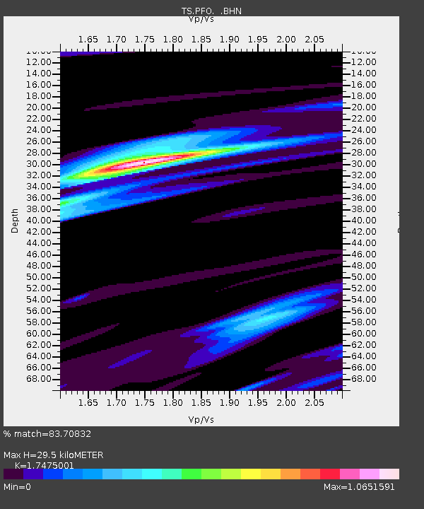
| Estimated Moho Depth: |
29.5 km |
| Estimated Crust Vp/Vs: |
1.75 |
| Assumed Crust Vp: |
6.264 km/s |
| Estimated Crust Vs: |
3.584 km/s |
| Estimated Crust Poisson's Ratio: |
0.26 |
|
| Radial Match: |
83.70832 % |
| Radial Bump: |
400 |
| Transverse Match: |
72.79284 % |
| Transverse Bump: |
400 |
| SOD ConfigId: |
17000 |
| Insert Time: |
2010-02-26 14:42:06.986 +0000 |
| GWidth: |
2.5 |
| Max Bumps: |
400 |
| Tol: |
0.001 |
|
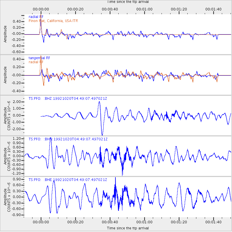
Signal To Noise
| Channel | StoN | STA | LTA |
| TS:PFO: :BHN:19921020T04:49:07.497021Z | 3.438564 | 3.2391725E-7 | 9.4201305E-8 |
| TS:PFO: :BHE:19921020T04:49:07.497021Z | 2.014727 | 2.8226583E-7 | 1.4010128E-7 |
| TS:PFO: :BHZ:19921020T04:49:07.497021Z | 3.575269 | 8.8468516E-7 | 2.4744577E-7 |
| Arrivals |
| Ps | 3.7 SECOND |
| PpPs | 12 SECOND |
| PsPs/PpSs | 16 SECOND |


