You are here: Home > Network List > TS - TERRAscope (Southern California Seismic Network) Stations List
> Station PFO Pinon Flat, California, USA > Earthquake Result Viewer
PFO Pinon Flat, California, USA - Earthquake Result Viewer
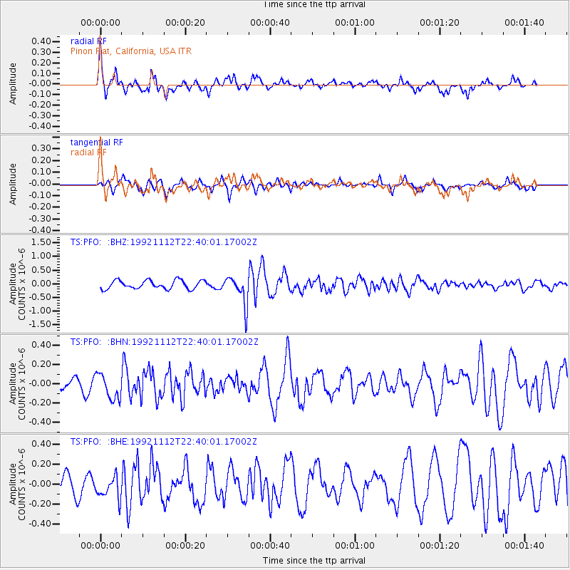
| Earthquake location: |
South Of Fiji Islands |
| Earthquake latitude/longitude: |
-22.4/-178.1 |
| Earthquake time(UTC): |
1992/11/12 (317) 22:28:58 GMT |
| Earthquake Depth: |
368 km |
| Earthquake Magnitude: |
5.9 MB |
| Earthquake Catalog/Contributor: |
WHDF/NEIC |
|
| Network: |
TS TERRAscope (Southern California Seismic Network) |
| Station: |
PFO Pinon Flat, California, USA |
| Lat/Lon: |
33.61 N/116.46 W |
| Elevation: |
1280 m |
|
| Distance: |
80.9 deg |
| Az: |
48.051 deg |
| Baz: |
235.592 deg |
| Ray Param: |
0.0469802 |
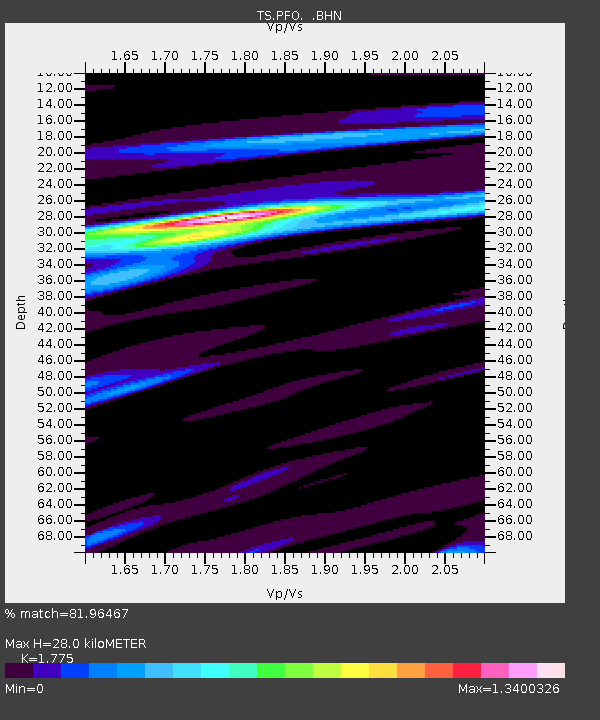
| Estimated Moho Depth: |
28.0 km |
| Estimated Crust Vp/Vs: |
1.77 |
| Assumed Crust Vp: |
6.264 km/s |
| Estimated Crust Vs: |
3.529 km/s |
| Estimated Crust Poisson's Ratio: |
0.27 |
|
| Radial Match: |
81.96467 % |
| Radial Bump: |
400 |
| Transverse Match: |
53.865303 % |
| Transverse Bump: |
303 |
| SOD ConfigId: |
17000 |
| Insert Time: |
2010-02-26 14:42:08.095 +0000 |
| GWidth: |
2.5 |
| Max Bumps: |
400 |
| Tol: |
0.001 |
|
Signal To Noise
| Channel | StoN | STA | LTA |
| TS:PFO: :BHN:19921112T22:40:01.17002Z | 1.3779198 | 1.369471E-7 | 9.938683E-8 |
| TS:PFO: :BHE:19921112T22:40:01.17002Z | 1.1705344 | 1.2922561E-7 | 1.10398815E-7 |
| TS:PFO: :BHZ:19921112T22:40:01.17002Z | 3.4768147 | 5.445507E-7 | 1.5662344E-7 |
| Arrivals |
| Ps | 3.6 SECOND |
| PpPs | 12 SECOND |
| PsPs/PpSs | 16 SECOND |


