You are here: Home > Network List > TA - USArray Transportable Network (new EarthScope stations) Stations List
> Station F20K Avaraart Lake, AK, USA > Earthquake Result Viewer
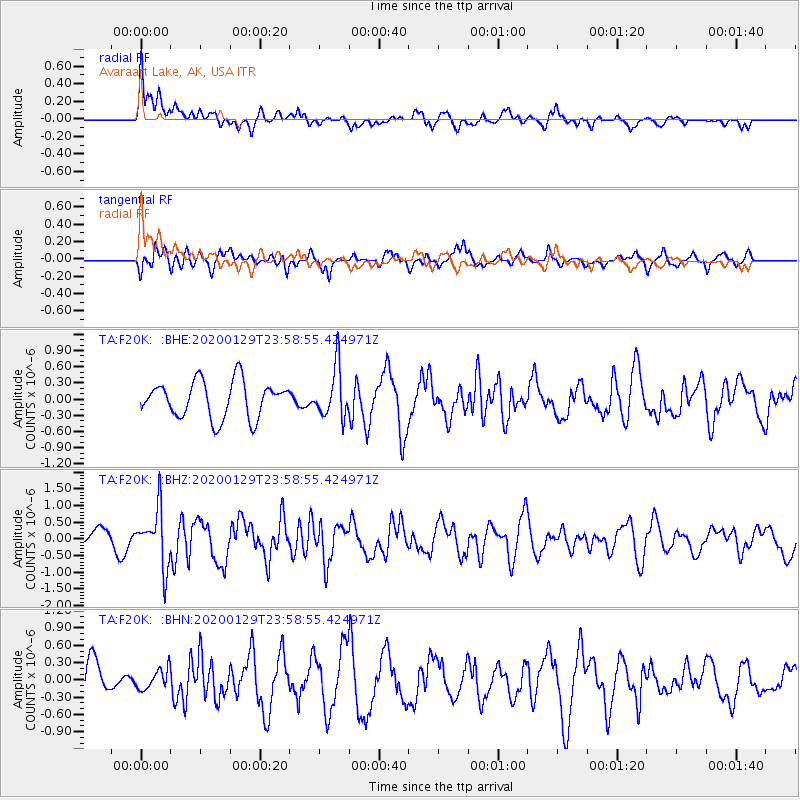
F20K Avaraart Lake, AK, USA - Earthquake Result Viewer
*The percent match for this event was below the threshold and hence no stack was calculated.
| Earthquake location: |
Northern Molucca Sea |
| Earthquake latitude/longitude: |
0.7/126.3 |
| Earthquake time(UTC): |
2020/01/29 (029) 23:46:54 GMT |
| Earthquake Depth: |
15 km |
| Earthquake Magnitude: |
5.7 mww |
| Earthquake Catalog/Contributor: |
NEIC PDE/us |
|
| Network: |
TA USArray Transportable Network (new EarthScope stations) |
| Station: |
F20K Avaraart Lake, AK, USA |
| Lat/Lon: |
67.05 N/155.73 W |
| Elevation: |
136 m |
|
| Distance: |
84.6 deg |
| Az: |
22.658 deg |
| Baz: |
259.179 deg |
| Ray Param: |
$rayparam |
*The percent match for this event was below the threshold and hence was not used in the summary stack. |
|
| Radial Match: |
64.86704 % |
| Radial Bump: |
400 |
| Transverse Match: |
58.284172 % |
| Transverse Bump: |
400 |
| SOD ConfigId: |
20465011 |
| Insert Time: |
2020-02-17 01:30:44.054 +0000 |
| GWidth: |
2.5 |
| Max Bumps: |
400 |
| Tol: |
0.001 |
|
Signal To Noise
| Channel | StoN | STA | LTA |
| TA:F20K: :BHZ:20200129T23:58:55.424971Z | 3.6413758 | 8.4881674E-7 | 2.3310331E-7 |
| TA:F20K: :BHN:20200129T23:58:55.424971Z | 0.35322157 | 1.7761172E-7 | 5.0283376E-7 |
| TA:F20K: :BHE:20200129T23:58:55.424971Z | 1.3766824 | 4.6500566E-7 | 3.3777266E-7 |
| Arrivals |
| Ps | |
| PpPs | |
| PsPs/PpSs | |


