You are here: Home > Network List > AZ - ANZA Regional Network Stations List
> Station SMER AZ.SMER > Earthquake Result Viewer
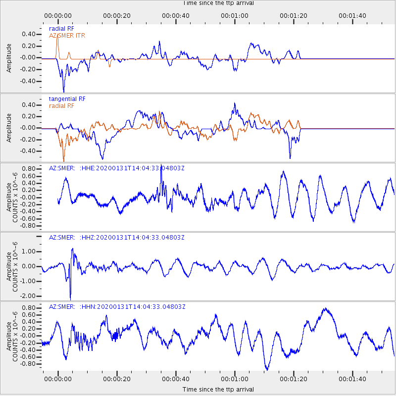
SMER AZ.SMER - Earthquake Result Viewer
*The percent match for this event was below the threshold and hence no stack was calculated.
| Earthquake location: |
South Of Fiji Islands |
| Earthquake latitude/longitude: |
-25.4/178.5 |
| Earthquake time(UTC): |
2020/01/31 (031) 13:53:30 GMT |
| Earthquake Depth: |
576 km |
| Earthquake Magnitude: |
5.7 mww |
| Earthquake Catalog/Contributor: |
NEIC PDE/us |
|
| Network: |
AZ ANZA Regional Network |
| Station: |
SMER AZ.SMER |
| Lat/Lon: |
33.46 N/117.17 W |
| Elevation: |
355 m |
|
| Distance: |
84.6 deg |
| Az: |
49.187 deg |
| Baz: |
234.995 deg |
| Ray Param: |
$rayparam |
*The percent match for this event was below the threshold and hence was not used in the summary stack. |
|
| Radial Match: |
58.06564 % |
| Radial Bump: |
400 |
| Transverse Match: |
38.315426 % |
| Transverse Bump: |
400 |
| SOD ConfigId: |
20465011 |
| Insert Time: |
2020-02-19 06:33:51.615 +0000 |
| GWidth: |
2.5 |
| Max Bumps: |
400 |
| Tol: |
0.001 |
|
Signal To Noise
| Channel | StoN | STA | LTA |
| AZ:SMER: :HHZ:20200131T14:04:33.04803Z | 3.3279457 | 6.3715345E-7 | 1.9145548E-7 |
| AZ:SMER: :HHN:20200131T14:04:33.04803Z | 0.8506647 | 3.7661238E-7 | 4.4272718E-7 |
| AZ:SMER: :HHE:20200131T14:04:33.04803Z | 0.58614415 | 1.2023092E-7 | 2.0512176E-7 |
| Arrivals |
| Ps | |
| PpPs | |
| PsPs/PpSs | |


