You are here: Home > Network List > TS - TERRAscope (Southern California Seismic Network) Stations List
> Station PFO Pinon Flat, California, USA > Earthquake Result Viewer
PFO Pinon Flat, California, USA - Earthquake Result Viewer
| Earthquake location: |
Near West Coast Of Honshu, Japan |
| Earthquake latitude/longitude: |
37.6/137.3 |
| Earthquake time(UTC): |
1993/02/07 (038) 13:27:43 GMT |
| Earthquake Depth: |
24 km |
| Earthquake Magnitude: |
6.3 MB, 6.1 MS |
| Earthquake Catalog/Contributor: |
WHDF/NEIC |
|
| Network: |
TS TERRAscope (Southern California Seismic Network) |
| Station: |
PFO Pinon Flat, California, USA |
| Lat/Lon: |
33.61 N/116.46 W |
| Elevation: |
1280 m |
|
| Distance: |
81.4 deg |
| Az: |
54.106 deg |
| Baz: |
309.566 deg |
| Ray Param: |
0.04756429 |
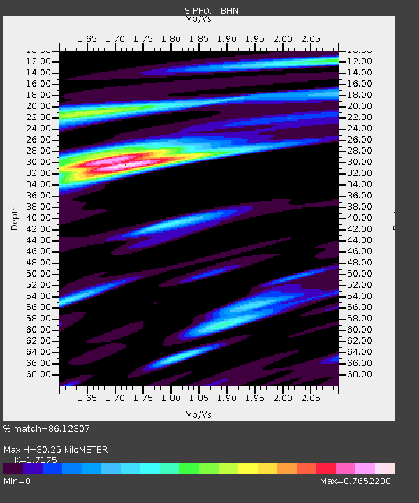
| Estimated Moho Depth: |
30.25 km |
| Estimated Crust Vp/Vs: |
1.72 |
| Assumed Crust Vp: |
6.264 km/s |
| Estimated Crust Vs: |
3.647 km/s |
| Estimated Crust Poisson's Ratio: |
0.24 |
|
| Radial Match: |
86.12307 % |
| Radial Bump: |
400 |
| Transverse Match: |
78.61615 % |
| Transverse Bump: |
400 |
| SOD ConfigId: |
16938 |
| Insert Time: |
2010-02-26 14:42:17.866 +0000 |
| GWidth: |
2.5 |
| Max Bumps: |
400 |
| Tol: |
0.001 |
|
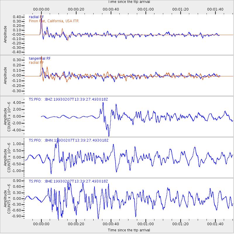
Signal To Noise
| Channel | StoN | STA | LTA |
| TS:PFO: :BHN:19930207T13:39:27.493018Z | 1.1790206 | 1.9361798E-7 | 1.6421934E-7 |
| TS:PFO: :BHE:19930207T13:39:27.493018Z | 1.3620348 | 1.7943638E-7 | 1.317414E-7 |
| TS:PFO: :BHZ:19930207T13:39:27.493018Z | 3.3656776 | 7.5279826E-7 | 2.2366915E-7 |
| Arrivals |
| Ps | 3.6 SECOND |
| PpPs | 13 SECOND |
| PsPs/PpSs | 16 SECOND |


