You are here: Home > Network List > US - United States National Seismic Network Stations List
> Station MSO Missoula, Montana, USA > Earthquake Result Viewer
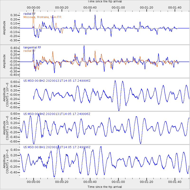
MSO Missoula, Montana, USA - Earthquake Result Viewer
*The percent match for this event was below the threshold and hence no stack was calculated.
| Earthquake location: |
South Of Fiji Islands |
| Earthquake latitude/longitude: |
-25.4/178.5 |
| Earthquake time(UTC): |
2020/01/31 (031) 13:53:30 GMT |
| Earthquake Depth: |
576 km |
| Earthquake Magnitude: |
5.7 mww |
| Earthquake Catalog/Contributor: |
NEIC PDE/us |
|
| Network: |
US United States National Seismic Network |
| Station: |
MSO Missoula, Montana, USA |
| Lat/Lon: |
46.83 N/113.94 W |
| Elevation: |
1264 m |
|
| Distance: |
94.2 deg |
| Az: |
39.518 deg |
| Baz: |
236.98 deg |
| Ray Param: |
$rayparam |
*The percent match for this event was below the threshold and hence was not used in the summary stack. |
|
| Radial Match: |
37.399277 % |
| Radial Bump: |
290 |
| Transverse Match: |
63.044342 % |
| Transverse Bump: |
337 |
| SOD ConfigId: |
20465011 |
| Insert Time: |
2020-02-19 08:28:20.625 +0000 |
| GWidth: |
2.5 |
| Max Bumps: |
400 |
| Tol: |
0.001 |
|
Signal To Noise
| Channel | StoN | STA | LTA |
| US:MSO:00:BHZ:20200131T14:05:17.249996Z | 3.570318 | 4.585004E-7 | 1.2842006E-7 |
| US:MSO:00:BH1:20200131T14:05:17.249996Z | 0.44041413 | 9.360789E-8 | 2.1254515E-7 |
| US:MSO:00:BH2:20200131T14:05:17.249996Z | 2.079061 | 2.8374603E-7 | 1.3647796E-7 |
| Arrivals |
| Ps | |
| PpPs | |
| PsPs/PpSs | |


