You are here: Home > Network List > TS - TERRAscope (Southern California Seismic Network) Stations List
> Station PFO Pinon Flat, California, USA > Earthquake Result Viewer
PFO Pinon Flat, California, USA - Earthquake Result Viewer
| Earthquake location: |
Fiji Islands Region |
| Earthquake latitude/longitude: |
-14.3/-178.3 |
| Earthquake time(UTC): |
1993/03/12 (071) 14:01:38 GMT |
| Earthquake Depth: |
33 km |
| Earthquake Magnitude: |
5.9 MB, 6.5 MS |
| Earthquake Catalog/Contributor: |
WHDF/NEIC |
|
| Network: |
TS TERRAscope (Southern California Seismic Network) |
| Station: |
PFO Pinon Flat, California, USA |
| Lat/Lon: |
33.61 N/116.46 W |
| Elevation: |
1280 m |
|
| Distance: |
75.8 deg |
| Az: |
49.386 deg |
| Baz: |
241.836 deg |
| Ray Param: |
0.05140539 |
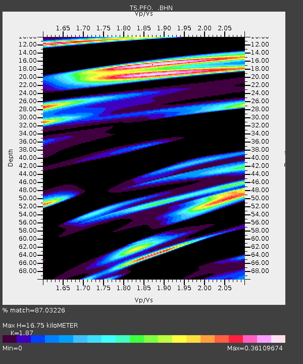
| Estimated Moho Depth: |
16.75 km |
| Estimated Crust Vp/Vs: |
1.87 |
| Assumed Crust Vp: |
6.264 km/s |
| Estimated Crust Vs: |
3.35 km/s |
| Estimated Crust Poisson's Ratio: |
0.30 |
|
| Radial Match: |
87.03226 % |
| Radial Bump: |
384 |
| Transverse Match: |
80.655556 % |
| Transverse Bump: |
400 |
| SOD ConfigId: |
16938 |
| Insert Time: |
2010-02-26 14:42:18.856 +0000 |
| GWidth: |
2.5 |
| Max Bumps: |
400 |
| Tol: |
0.001 |
|
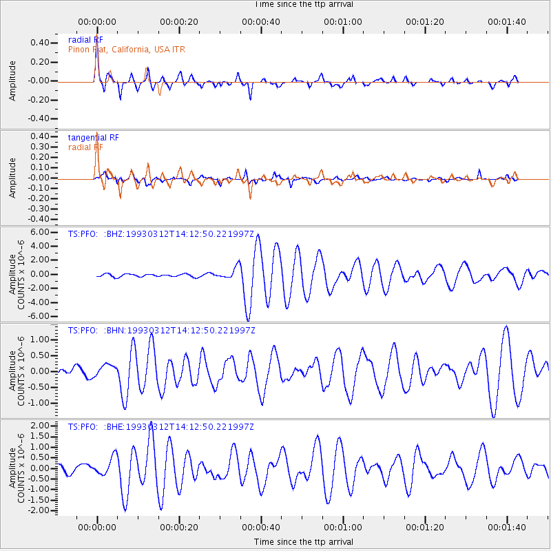
Signal To Noise
| Channel | StoN | STA | LTA |
| TS:PFO: :BHN:19930312T14:12:50.221997Z | 1.1522423 | 1.9582207E-7 | 1.6994869E-7 |
| TS:PFO: :BHE:19930312T14:12:50.221997Z | 2.5232334 | 4.4201178E-7 | 1.7517672E-7 |
| TS:PFO: :BHZ:19930312T14:12:50.221997Z | 4.315726 | 8.700466E-7 | 2.0159914E-7 |
| Arrivals |
| Ps | 2.4 SECOND |
| PpPs | 7.5 SECOND |
| PsPs/PpSs | 9.9 SECOND |


