You are here: Home > Network List > TS - TERRAscope (Southern California Seismic Network) Stations List
> Station PFO Pinon Flat, California, USA > Earthquake Result Viewer
PFO Pinon Flat, California, USA - Earthquake Result Viewer
| Earthquake location: |
Mariana Islands |
| Earthquake latitude/longitude: |
15.7/146.6 |
| Earthquake time(UTC): |
1993/06/06 (157) 13:23:27 GMT |
| Earthquake Depth: |
68 km |
| Earthquake Magnitude: |
5.8 MB, 6.4 UNKNOWN |
| Earthquake Catalog/Contributor: |
WHDF/NEIC |
|
| Network: |
TS TERRAscope (Southern California Seismic Network) |
| Station: |
PFO Pinon Flat, California, USA |
| Lat/Lon: |
33.61 N/116.46 W |
| Elevation: |
1280 m |
|
| Distance: |
87.1 deg |
| Az: |
56.04 deg |
| Baz: |
286.792 deg |
| Ray Param: |
0.04343267 |
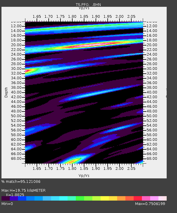
| Estimated Moho Depth: |
19.75 km |
| Estimated Crust Vp/Vs: |
1.88 |
| Assumed Crust Vp: |
6.264 km/s |
| Estimated Crust Vs: |
3.327 km/s |
| Estimated Crust Poisson's Ratio: |
0.30 |
|
| Radial Match: |
95.121086 % |
| Radial Bump: |
400 |
| Transverse Match: |
86.87414 % |
| Transverse Bump: |
400 |
| SOD ConfigId: |
16938 |
| Insert Time: |
2010-02-26 14:42:19.946 +0000 |
| GWidth: |
2.5 |
| Max Bumps: |
400 |
| Tol: |
0.001 |
|
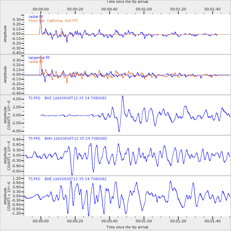
Signal To Noise
| Channel | StoN | STA | LTA |
| TS:PFO: :BHN:19930606T13:35:34.708008Z | 1.2660534 | 8.765503E-8 | 6.923486E-8 |
| TS:PFO: :BHE:19930606T13:35:34.708008Z | 1.1142149 | 9.937365E-8 | 8.9187154E-8 |
| TS:PFO: :BHZ:19930606T13:35:34.708008Z | 1.8746203 | 1.7845178E-7 | 9.519356E-8 |
| Arrivals |
| Ps | 2.8 SECOND |
| PpPs | 8.9 SECOND |
| PsPs/PpSs | 12 SECOND |


