You are here: Home > Network List > TS - TERRAscope (Southern California Seismic Network) Stations List
> Station PFO Pinon Flat, California, USA > Earthquake Result Viewer
PFO Pinon Flat, California, USA - Earthquake Result Viewer
| Earthquake location: |
San Juan Province, Argentina |
| Earthquake latitude/longitude: |
-31.6/-69.2 |
| Earthquake time(UTC): |
1993/06/08 (159) 23:17:41 GMT |
| Earthquake Depth: |
113 km |
| Earthquake Magnitude: |
6.4 MB, 6.4 UNKNOWN |
| Earthquake Catalog/Contributor: |
WHDF/NEIC |
|
| Network: |
TS TERRAscope (Southern California Seismic Network) |
| Station: |
PFO Pinon Flat, California, USA |
| Lat/Lon: |
33.61 N/116.46 W |
| Elevation: |
1280 m |
|
| Distance: |
78.7 deg |
| Az: |
321.331 deg |
| Baz: |
140.291 deg |
| Ray Param: |
0.049218785 |
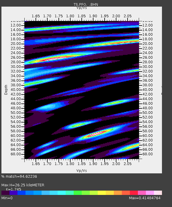
| Estimated Moho Depth: |
26.25 km |
| Estimated Crust Vp/Vs: |
1.75 |
| Assumed Crust Vp: |
6.264 km/s |
| Estimated Crust Vs: |
3.589 km/s |
| Estimated Crust Poisson's Ratio: |
0.26 |
|
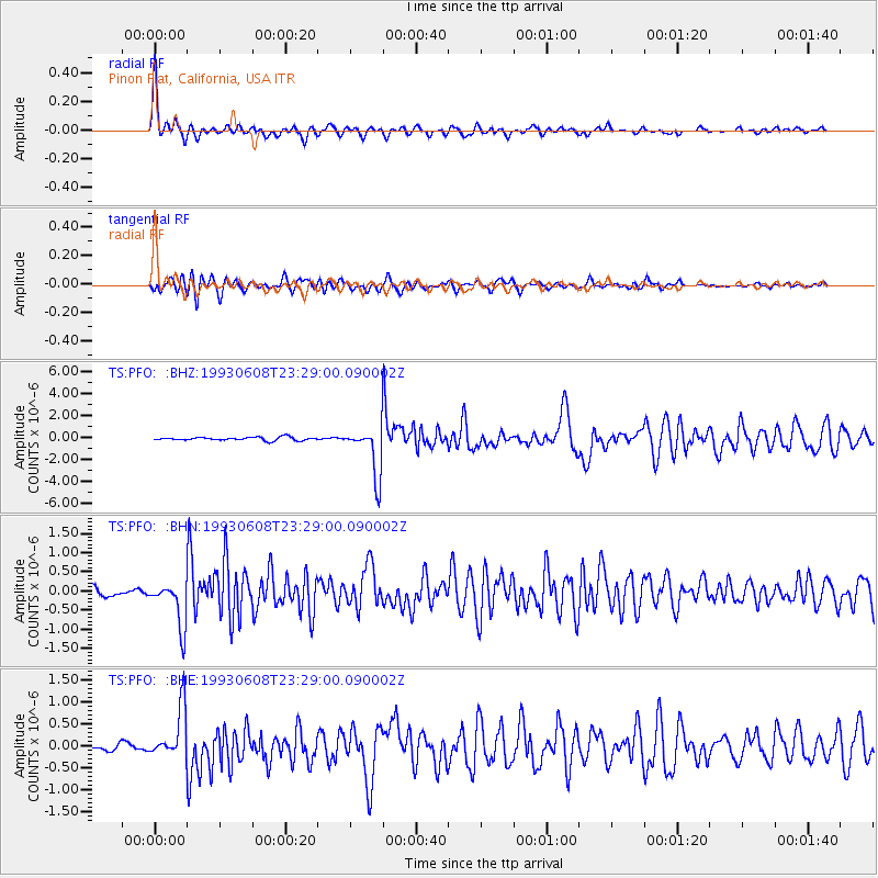
| Radial Match: |
94.62236 % |
| Radial Bump: |
339 |
| Transverse Match: |
86.32784 % |
| Transverse Bump: |
400 |
| SOD ConfigId: |
16938 |
| Insert Time: |
2010-02-26 14:42:22.992 +0000 |
| GWidth: |
2.5 |
| Max Bumps: |
400 |
| Tol: |
0.001 |
|
Signal To Noise
| Channel | StoN | STA | LTA |
| TS:PFO: :BHN:19930608T23:29:00.090002Z | 4.783005 | 6.0314125E-7 | 1.2610089E-7 |
| TS:PFO: :BHE:19930608T23:29:00.090002Z | 6.495921 | 5.875537E-7 | 9.044964E-8 |
| TS:PFO: :BHZ:19930608T23:29:00.090002Z | 15.124958 | 2.2608142E-6 | 1.4947574E-7 |
| Arrivals |
| Ps | 3.2 SECOND |
| PpPs | 11 SECOND |
| PsPs/PpSs | 14 SECOND |


