You are here: Home > Network List > TA - USArray Transportable Network (new EarthScope stations) Stations List
> Station F21K Alatna River, AK, USA > Earthquake Result Viewer
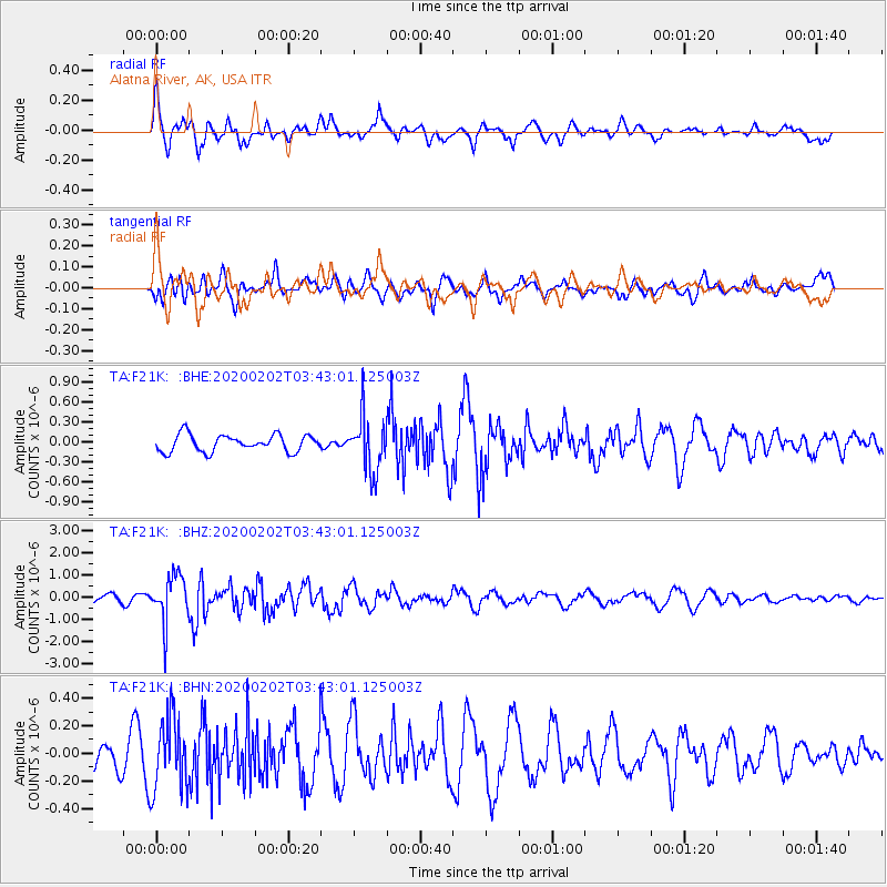
F21K Alatna River, AK, USA - Earthquake Result Viewer
*The percent match for this event was below the threshold and hence no stack was calculated.
| Earthquake location: |
Off Coast Of Chiapas, Mexico |
| Earthquake latitude/longitude: |
13.8/-92.8 |
| Earthquake time(UTC): |
2020/02/02 (033) 03:32:44 GMT |
| Earthquake Depth: |
10 km |
| Earthquake Magnitude: |
5.6 Mww |
| Earthquake Catalog/Contributor: |
NEIC PDE/us |
|
| Network: |
TA USArray Transportable Network (new EarthScope stations) |
| Station: |
F21K Alatna River, AK, USA |
| Lat/Lon: |
67.22 N/153.48 W |
| Elevation: |
597 m |
|
| Distance: |
66.2 deg |
| Az: |
338.224 deg |
| Baz: |
112.238 deg |
| Ray Param: |
$rayparam |
*The percent match for this event was below the threshold and hence was not used in the summary stack. |
|
| Radial Match: |
76.14865 % |
| Radial Bump: |
400 |
| Transverse Match: |
55.500484 % |
| Transverse Bump: |
400 |
| SOD ConfigId: |
20465011 |
| Insert Time: |
2020-02-20 13:34:52.978 +0000 |
| GWidth: |
2.5 |
| Max Bumps: |
400 |
| Tol: |
0.001 |
|
Signal To Noise
| Channel | StoN | STA | LTA |
| TA:F21K: :BHZ:20200202T03:43:01.125003Z | 6.6181726 | 1.035693E-6 | 1.5649229E-7 |
| TA:F21K: :BHN:20200202T03:43:01.125003Z | 1.7642492 | 2.6017946E-7 | 1.4747319E-7 |
| TA:F21K: :BHE:20200202T03:43:01.125003Z | 3.2489612 | 4.1160234E-7 | 1.2668737E-7 |
| Arrivals |
| Ps | |
| PpPs | |
| PsPs/PpSs | |


