You are here: Home > Network List > TS - TERRAscope (Southern California Seismic Network) Stations List
> Station PFO Pinon Flat, California, USA > Earthquake Result Viewer
PFO Pinon Flat, California, USA - Earthquake Result Viewer

| Earthquake location: |
South Of Fiji Islands |
| Earthquake latitude/longitude: |
-23.9/179.8 |
| Earthquake time(UTC): |
1993/08/07 (219) 17:53:27 GMT |
| Earthquake Depth: |
555 km |
| Earthquake Magnitude: |
6.0 MB, 5.9 UNKNOWN, 6.9 MW |
| Earthquake Catalog/Contributor: |
WHDF/NEIC |
|
| Network: |
TS TERRAscope (Southern California Seismic Network) |
| Station: |
PFO Pinon Flat, California, USA |
| Lat/Lon: |
33.61 N/116.46 W |
| Elevation: |
1280 m |
|
| Distance: |
83.3 deg |
| Az: |
48.891 deg |
| Baz: |
235.742 deg |
| Ray Param: |
0.04464945 |
| Estimated Moho Depth: |
30.25 km |
| Estimated Crust Vp/Vs: |
1.61 |
| Assumed Crust Vp: |
6.264 km/s |
| Estimated Crust Vs: |
3.89 km/s |
| Estimated Crust Poisson's Ratio: |
0.19 |
|
| Radial Match: |
90.522804 % |
| Radial Bump: |
400 |
| Transverse Match: |
81.53702 % |
| Transverse Bump: |
400 |
| SOD ConfigId: |
16938 |
| Insert Time: |
2010-02-26 14:42:24.128 +0000 |
| GWidth: |
2.5 |
| Max Bumps: |
400 |
| Tol: |
0.001 |
|
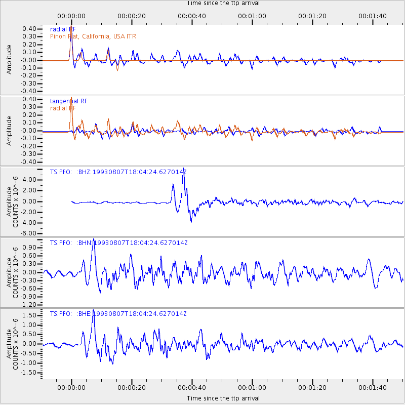
Signal To Noise
| Channel | StoN | STA | LTA |
| TS:PFO: :BHN:19930807T18:04:24.627014Z | 1.9942163 | 1.7301717E-7 | 8.675948E-8 |
| TS:PFO: :BHE:19930807T18:04:24.627014Z | 4.1172667 | 2.4384505E-7 | 5.9224988E-8 |
| TS:PFO: :BHZ:19930807T18:04:24.627014Z | 10.487661 | 1.1105136E-6 | 1.05887636E-7 |
| Arrivals |
| Ps | 3.0 SECOND |
| PpPs | 12 SECOND |
| PsPs/PpSs | 15 SECOND |


