You are here: Home > Network List > US - United States National Seismic Network Stations List
> Station MSO Missoula, Montana, USA > Earthquake Result Viewer
MSO Missoula, Montana, USA - Earthquake Result Viewer
*The percent match for this event was below the threshold and hence no stack was calculated.
| Earthquake location: |
Off Coast Of Chiapas, Mexico |
| Earthquake latitude/longitude: |
13.8/-92.8 |
| Earthquake time(UTC): |
2020/02/02 (033) 03:32:44 GMT |
| Earthquake Depth: |
10 km |
| Earthquake Magnitude: |
5.6 Mww |
| Earthquake Catalog/Contributor: |
NEIC PDE/us |
|
| Network: |
US United States National Seismic Network |
| Station: |
MSO Missoula, Montana, USA |
| Lat/Lon: |
46.83 N/113.94 W |
| Elevation: |
1264 m |
|
| Distance: |
37.4 deg |
| Az: |
335.962 deg |
| Baz: |
144.806 deg |
| Ray Param: |
$rayparam |
*The percent match for this event was below the threshold and hence was not used in the summary stack. |
|
| Radial Match: |
73.66801 % |
| Radial Bump: |
400 |
| Transverse Match: |
67.68196 % |
| Transverse Bump: |
400 |
| SOD ConfigId: |
20465011 |
| Insert Time: |
2020-02-20 13:51:25.481 +0000 |
| GWidth: |
2.5 |
| Max Bumps: |
400 |
| Tol: |
0.001 |
|
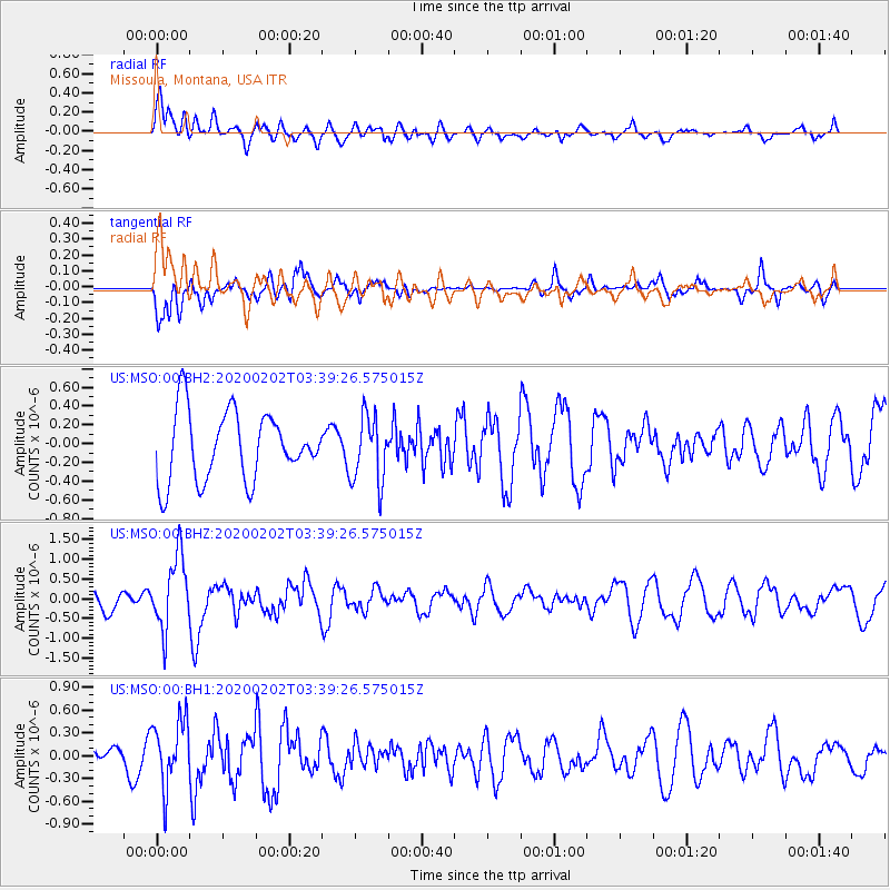
Signal To Noise
| Channel | StoN | STA | LTA |
| US:MSO:00:BHZ:20200202T03:39:26.575015Z | 1.923248 | 9.1414836E-7 | 4.7531483E-7 |
| US:MSO:00:BH1:20200202T03:39:26.575015Z | 1.8236017 | 4.347674E-7 | 2.3841137E-7 |
| US:MSO:00:BH2:20200202T03:39:26.575015Z | 0.97931844 | 3.5599808E-7 | 3.6351616E-7 |
| Arrivals |
| Ps | |
| PpPs | |
| PsPs/PpSs | |


