You are here: Home > Network List > TS - TERRAscope (Southern California Seismic Network) Stations List
> Station PFO Pinon Flat, California, USA > Earthquake Result Viewer
PFO Pinon Flat, California, USA - Earthquake Result Viewer
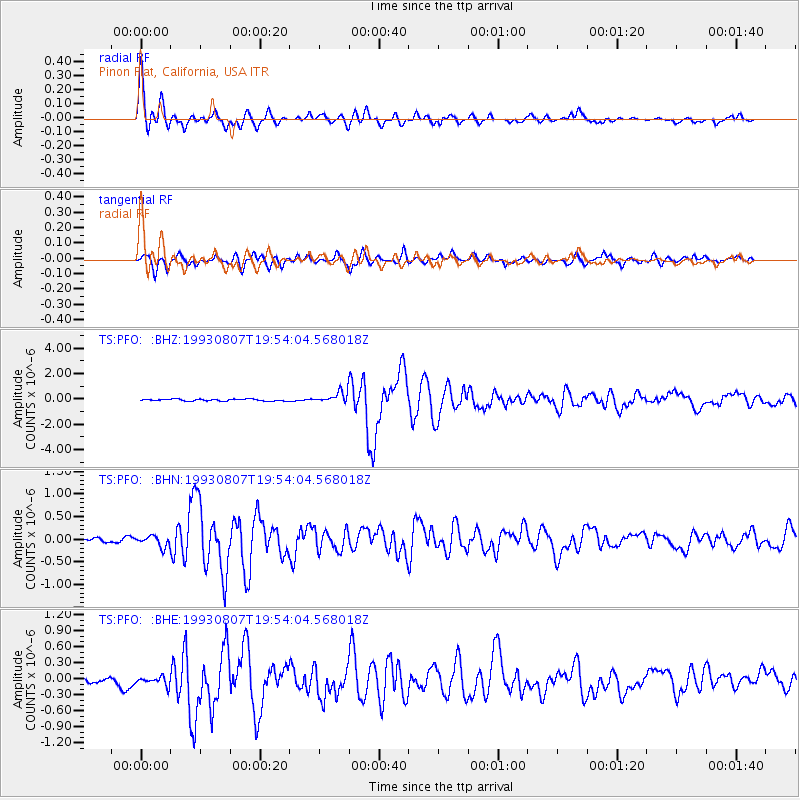
| Earthquake location: |
Hokkaido, Japan Region |
| Earthquake latitude/longitude: |
42.0/139.9 |
| Earthquake time(UTC): |
1993/08/07 (219) 19:42:43 GMT |
| Earthquake Depth: |
26 km |
| Earthquake Magnitude: |
6.2 MB, 6.0 MS, 5.6 UNKNOWN, 6.3 MW |
| Earthquake Catalog/Contributor: |
WHDF/NEIC |
|
| Network: |
TS TERRAscope (Southern California Seismic Network) |
| Station: |
PFO Pinon Flat, California, USA |
| Lat/Lon: |
33.61 N/116.46 W |
| Elevation: |
1280 m |
|
| Distance: |
77.3 deg |
| Az: |
56.219 deg |
| Baz: |
312.025 deg |
| Ray Param: |
0.050380375 |
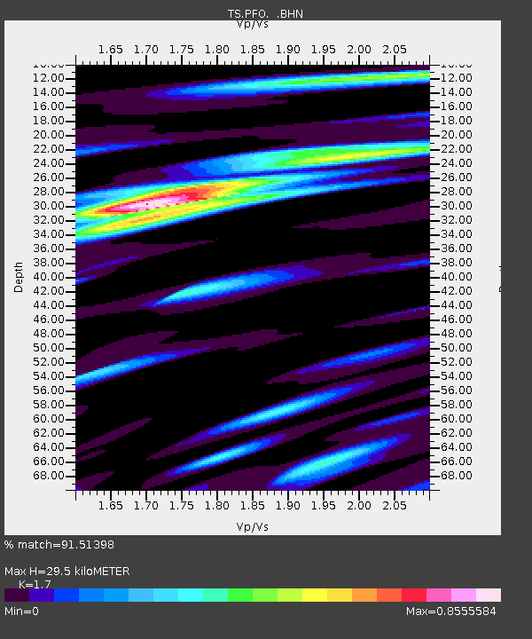
| Estimated Moho Depth: |
29.5 km |
| Estimated Crust Vp/Vs: |
1.70 |
| Assumed Crust Vp: |
6.264 km/s |
| Estimated Crust Vs: |
3.684 km/s |
| Estimated Crust Poisson's Ratio: |
0.24 |
|
| Radial Match: |
91.51398 % |
| Radial Bump: |
400 |
| Transverse Match: |
84.184166 % |
| Transverse Bump: |
400 |
| SOD ConfigId: |
16938 |
| Insert Time: |
2010-02-26 14:42:25.266 +0000 |
| GWidth: |
2.5 |
| Max Bumps: |
400 |
| Tol: |
0.001 |
|
Signal To Noise
| Channel | StoN | STA | LTA |
| TS:PFO: :BHN:19930807T19:54:04.568018Z | 1.5843116 | 1.1957016E-7 | 7.547137E-8 |
| TS:PFO: :BHE:19930807T19:54:04.568018Z | 1.137415 | 1.10668694E-7 | 9.729843E-8 |
| TS:PFO: :BHZ:19930807T19:54:04.568018Z | 5.7301564 | 4.1261038E-7 | 7.200682E-8 |
| Arrivals |
| Ps | 3.4 SECOND |
| PpPs | 12 SECOND |
| PsPs/PpSs | 16 SECOND |


