You are here: Home > Network List > UW - Pacific Northwest Regional Seismic Network Stations List
> Station UMAT Pilot Rock, OR, USA > Earthquake Result Viewer
UMAT Pilot Rock, OR, USA - Earthquake Result Viewer
*The percent match for this event was below the threshold and hence no stack was calculated.
| Earthquake location: |
Off Coast Of Chiapas, Mexico |
| Earthquake latitude/longitude: |
13.8/-92.8 |
| Earthquake time(UTC): |
2020/02/02 (033) 03:32:44 GMT |
| Earthquake Depth: |
10 km |
| Earthquake Magnitude: |
5.6 Mww |
| Earthquake Catalog/Contributor: |
NEIC PDE/us |
|
| Network: |
UW Pacific Northwest Regional Seismic Network |
| Station: |
UMAT Pilot Rock, OR, USA |
| Lat/Lon: |
45.29 N/118.96 W |
| Elevation: |
1318 m |
|
| Distance: |
38.4 deg |
| Az: |
329.974 deg |
| Baz: |
136.475 deg |
| Ray Param: |
$rayparam |
*The percent match for this event was below the threshold and hence was not used in the summary stack. |
|
| Radial Match: |
74.21082 % |
| Radial Bump: |
400 |
| Transverse Match: |
31.161036 % |
| Transverse Bump: |
350 |
| SOD ConfigId: |
20465011 |
| Insert Time: |
2020-02-20 14:00:14.837 +0000 |
| GWidth: |
2.5 |
| Max Bumps: |
400 |
| Tol: |
0.001 |
|
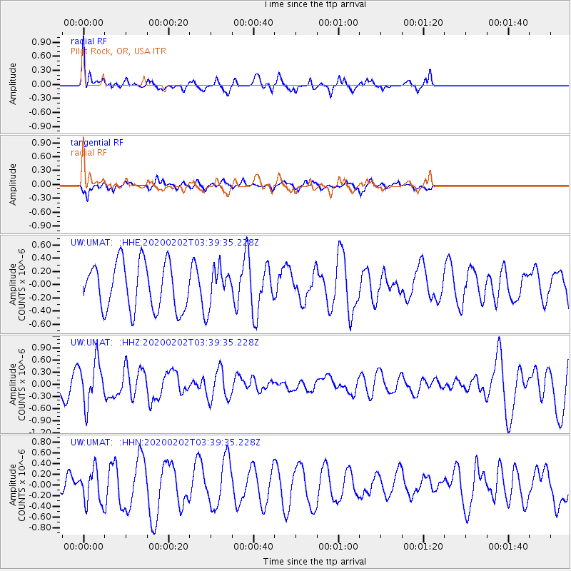
Signal To Noise
| Channel | StoN | STA | LTA |
| UW:UMAT: :HHZ:20200202T03:39:35.228Z | 1.6295817 | 5.29947E-7 | 3.2520433E-7 |
| UW:UMAT: :HHN:20200202T03:39:35.228Z | 2.2368186 | 3.150091E-7 | 1.4082909E-7 |
| UW:UMAT: :HHE:20200202T03:39:35.228Z | 0.77442384 | 2.7592043E-7 | 3.5629125E-7 |
| Arrivals |
| Ps | |
| PpPs | |
| PsPs/PpSs | |


