You are here: Home > Network List > G - GEOSCOPE Stations List
> Station MPG Montagne des Peres, French Guyana > Earthquake Result Viewer
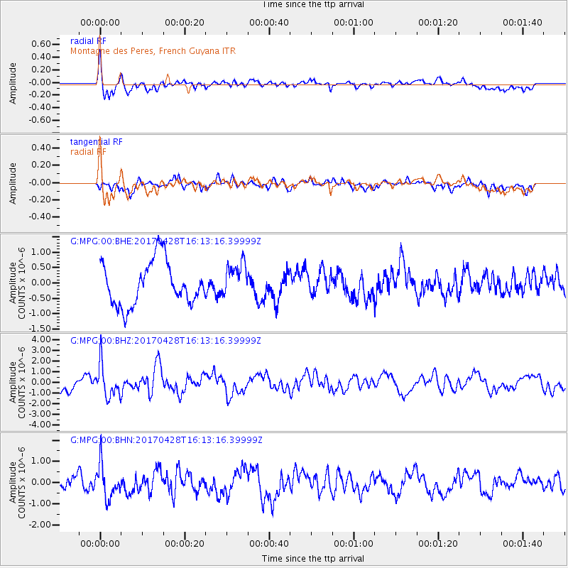
MPG Montagne des Peres, French Guyana - Earthquake Result Viewer
*The percent match for this event was below the threshold and hence no stack was calculated.
| Earthquake location: |
Near Coast Of Central Chile |
| Earthquake latitude/longitude: |
-33.1/-71.8 |
| Earthquake time(UTC): |
2017/04/28 (118) 16:05:55 GMT |
| Earthquake Depth: |
14 km |
| Earthquake Magnitude: |
5.7 Mww |
| Earthquake Catalog/Contributor: |
NEIC PDE/us |
|
| Network: |
G GEOSCOPE |
| Station: |
MPG Montagne des Peres, French Guyana |
| Lat/Lon: |
5.11 N/52.64 W |
| Elevation: |
147 m |
|
| Distance: |
42.2 deg |
| Az: |
29.187 deg |
| Baz: |
204.258 deg |
| Ray Param: |
$rayparam |
*The percent match for this event was below the threshold and hence was not used in the summary stack. |
|
| Radial Match: |
71.227875 % |
| Radial Bump: |
400 |
| Transverse Match: |
43.315323 % |
| Transverse Bump: |
400 |
| SOD ConfigId: |
2028011 |
| Insert Time: |
2017-05-12 16:11:27.418 +0000 |
| GWidth: |
2.5 |
| Max Bumps: |
400 |
| Tol: |
0.001 |
|
Signal To Noise
| Channel | StoN | STA | LTA |
| G:MPG:00:BHZ:20170428T16:13:16.39999Z | 2.1335294 | 1.5608734E-6 | 7.3159214E-7 |
| G:MPG:00:BHN:20170428T16:13:16.39999Z | 2.2357438 | 8.093379E-7 | 3.6199938E-7 |
| G:MPG:00:BHE:20170428T16:13:16.39999Z | 0.8021461 | 5.664534E-7 | 7.061724E-7 |
| Arrivals |
| Ps | |
| PpPs | |
| PsPs/PpSs | |


