You are here: Home > Network List > GO - National Seismic Network of Georgia Stations List
> Station TBLG Delisi, Georgia > Earthquake Result Viewer
TBLG Delisi, Georgia - Earthquake Result Viewer
| Earthquake location: |
Java, Indonesia |
| Earthquake latitude/longitude: |
-6.1/113.1 |
| Earthquake time(UTC): |
2020/02/05 (036) 18:12:37 GMT |
| Earthquake Depth: |
592 km |
| Earthquake Magnitude: |
6.2 mww |
| Earthquake Catalog/Contributor: |
NEIC PDE/us |
|
| Network: |
GO National Seismic Network of Georgia |
| Station: |
TBLG Delisi, Georgia |
| Lat/Lon: |
41.73 N/44.74 E |
| Elevation: |
510 m |
|
| Distance: |
78.2 deg |
| Az: |
314.695 deg |
| Baz: |
109.185 deg |
| Ray Param: |
0.04795358 |
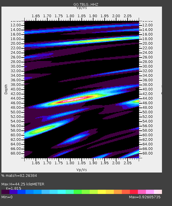
| Estimated Moho Depth: |
44.25 km |
| Estimated Crust Vp/Vs: |
1.82 |
| Assumed Crust Vp: |
6.291 km/s |
| Estimated Crust Vs: |
3.466 km/s |
| Estimated Crust Poisson's Ratio: |
0.28 |
|
| Radial Match: |
82.26384 % |
| Radial Bump: |
400 |
| Transverse Match: |
79.84374 % |
| Transverse Bump: |
400 |
| SOD ConfigId: |
20465011 |
| Insert Time: |
2020-02-21 17:25:29.268 +0000 |
| GWidth: |
2.5 |
| Max Bumps: |
400 |
| Tol: |
0.001 |
|
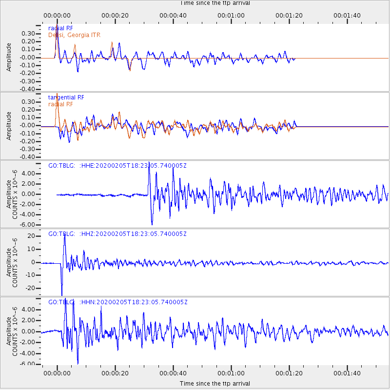
Signal To Noise
| Channel | StoN | STA | LTA |
| GO:TBLG: :HHZ:20200205T18:23:05.740005Z | 47.276134 | 8.596998E-6 | 1.8184646E-7 |
| GO:TBLG: :HHN:20200205T18:23:05.740005Z | 8.860898 | 1.9177812E-6 | 2.1643191E-7 |
| GO:TBLG: :HHE:20200205T18:23:05.740005Z | 26.584719 | 2.6401E-6 | 9.9308934E-8 |
| Arrivals |
| Ps | 5.9 SECOND |
| PpPs | 19 SECOND |
| PsPs/PpSs | 25 SECOND |


