You are here: Home > Network List > IU - Global Seismograph Network (GSN - IRIS/USGS) Stations List
> Station PMG Port Moresby, New Guinea > Earthquake Result Viewer
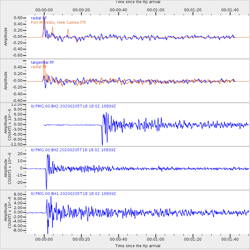
PMG Port Moresby, New Guinea - Earthquake Result Viewer

| Earthquake location: |
Java, Indonesia |
| Earthquake latitude/longitude: |
-6.1/113.1 |
| Earthquake time(UTC): |
2020/02/05 (036) 18:12:37 GMT |
| Earthquake Depth: |
592 km |
| Earthquake Magnitude: |
6.2 mww |
| Earthquake Catalog/Contributor: |
NEIC PDE/us |
|
| Network: |
IU Global Seismograph Network (GSN - IRIS/USGS) |
| Station: |
PMG Port Moresby, New Guinea |
| Lat/Lon: |
9.40 S/147.16 E |
| Elevation: |
90 m |
|
| Distance: |
33.9 deg |
| Az: |
97.784 deg |
| Baz: |
273.091 deg |
| Ray Param: |
0.07505463 |
| Estimated Moho Depth: |
39.0 km |
| Estimated Crust Vp/Vs: |
1.61 |
| Assumed Crust Vp: |
6.122 km/s |
| Estimated Crust Vs: |
3.797 km/s |
| Estimated Crust Poisson's Ratio: |
0.19 |
|
| Radial Match: |
92.70471 % |
| Radial Bump: |
400 |
| Transverse Match: |
90.40474 % |
| Transverse Bump: |
400 |
| SOD ConfigId: |
20465011 |
| Insert Time: |
2020-02-22 01:40:43.110 +0000 |
| GWidth: |
2.5 |
| Max Bumps: |
400 |
| Tol: |
0.001 |
|
Signal To Noise
| Channel | StoN | STA | LTA |
| IU:PMG:00:BHZ:20200205T18:18:02.16899Z | 74.07395 | 1.0025171E-5 | 1.3534003E-7 |
| IU:PMG:00:BH1:20200205T18:18:02.16899Z | 28.335323 | 3.1164477E-6 | 1.0998455E-7 |
| IU:PMG:00:BH2:20200205T18:18:02.16899Z | 46.629536 | 4.6550185E-6 | 9.9829826E-8 |
| Arrivals |
| Ps | 4.2 SECOND |
| PpPs | 16 SECOND |
| PsPs/PpSs | 20 SECOND |


