You are here: Home > Network List > MN - MEDNET Project Stations List
> Station VTS Vitosha, Bulgary > Earthquake Result Viewer
VTS Vitosha, Bulgary - Earthquake Result Viewer
| Earthquake location: |
Kuril Islands |
| Earthquake latitude/longitude: |
50.8/155.0 |
| Earthquake time(UTC): |
2009/04/21 (111) 05:26:11 GMT |
| Earthquake Depth: |
152 km |
| Earthquake Magnitude: |
6.0 MB, 6.2 MW, 6.2 MW |
| Earthquake Catalog/Contributor: |
WHDF/NEIC |
|
| Network: |
MN MEDNET Project |
| Station: |
VTS Vitosha, Bulgary |
| Lat/Lon: |
42.62 N/23.24 E |
| Elevation: |
1490 m |
|
| Distance: |
77.9 deg |
| Az: |
325.735 deg |
| Baz: |
28.927 deg |
| Ray Param: |
0.04964255 |
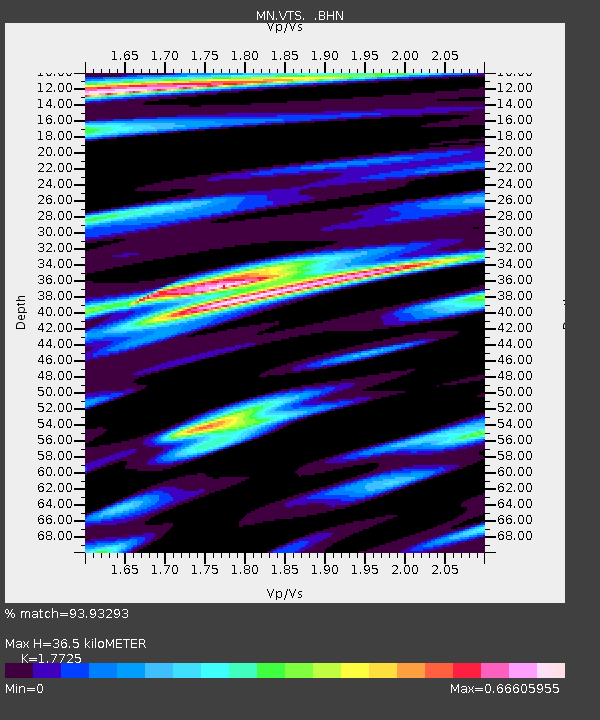
| Estimated Moho Depth: |
36.5 km |
| Estimated Crust Vp/Vs: |
1.77 |
| Assumed Crust Vp: |
6.291 km/s |
| Estimated Crust Vs: |
3.549 km/s |
| Estimated Crust Poisson's Ratio: |
0.27 |
|
| Radial Match: |
93.93293 % |
| Radial Bump: |
387 |
| Transverse Match: |
88.6827 % |
| Transverse Bump: |
400 |
| SOD ConfigId: |
2658 |
| Insert Time: |
2010-03-08 17:50:49.296 +0000 |
| GWidth: |
2.5 |
| Max Bumps: |
400 |
| Tol: |
0.001 |
|

Signal To Noise
| Channel | StoN | STA | LTA |
| MN:VTS: :BHN:20090421T05:37:21.413005Z | 25.430712 | 1.766169E-6 | 6.945024E-8 |
| MN:VTS: :BHE:20090421T05:37:21.413005Z | 18.907566 | 5.5347084E-7 | 2.9272455E-8 |
| MN:VTS: :BHZ:20090421T05:37:21.413005Z | 8.474109 | 2.4925444E-7 | 2.9413647E-8 |
| Arrivals |
| Ps | 4.6 SECOND |
| PpPs | 16 SECOND |
| PsPs/PpSs | 20 SECOND |


