You are here: Home > Network List > TS - TERRAscope (Southern California Seismic Network) Stations List
> Station PFO Pinon Flat, California, USA > Earthquake Result Viewer
PFO Pinon Flat, California, USA - Earthquake Result Viewer
| Earthquake location: |
Southeast Of Honshu, Japan |
| Earthquake latitude/longitude: |
32.0/137.9 |
| Earthquake time(UTC): |
1993/10/11 (284) 15:54:22 GMT |
| Earthquake Depth: |
365 km |
| Earthquake Magnitude: |
6.5 MB, 6.8 UNKNOWN, 6.9 MW |
| Earthquake Catalog/Contributor: |
WHDF/NEIC |
|
| Network: |
TS TERRAscope (Southern California Seismic Network) |
| Station: |
PFO Pinon Flat, California, USA |
| Lat/Lon: |
33.61 N/116.46 W |
| Elevation: |
1280 m |
|
| Distance: |
84.3 deg |
| Az: |
53.841 deg |
| Baz: |
304.718 deg |
| Ray Param: |
0.044596482 |
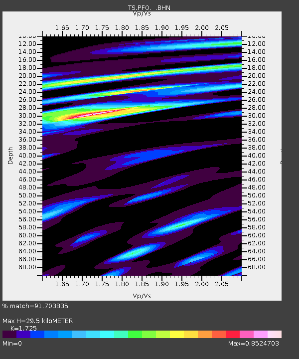
| Estimated Moho Depth: |
29.5 km |
| Estimated Crust Vp/Vs: |
1.73 |
| Assumed Crust Vp: |
6.264 km/s |
| Estimated Crust Vs: |
3.631 km/s |
| Estimated Crust Poisson's Ratio: |
0.25 |
|
| Radial Match: |
91.703835 % |
| Radial Bump: |
400 |
| Transverse Match: |
76.89067 % |
| Transverse Bump: |
400 |
| SOD ConfigId: |
16938 |
| Insert Time: |
2010-02-26 14:42:28.597 +0000 |
| GWidth: |
2.5 |
| Max Bumps: |
400 |
| Tol: |
0.001 |
|

Signal To Noise
| Channel | StoN | STA | LTA |
| TS:PFO: :BHN:19931011T16:05:43.134009Z | 9.022894 | 1.1036084E-6 | 1.2231202E-7 |
| TS:PFO: :BHE:19931011T16:05:43.134009Z | 10.729923 | 1.5679527E-6 | 1.4612898E-7 |
| TS:PFO: :BHZ:19931011T16:05:43.134009Z | 44.673443 | 7.113667E-6 | 1.5923705E-7 |
| Arrivals |
| Ps | 3.5 SECOND |
| PpPs | 13 SECOND |
| PsPs/PpSs | 16 SECOND |


