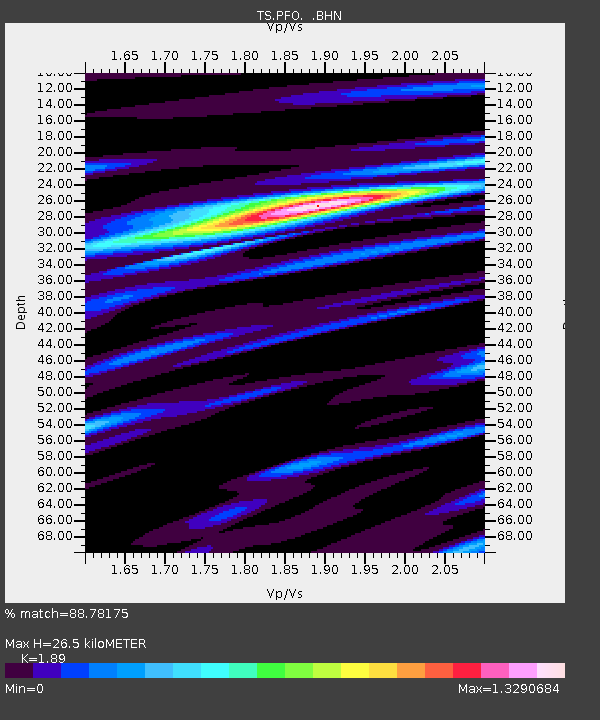
PFO Pinon Flat, California, USA - Earthquake Result Viewer
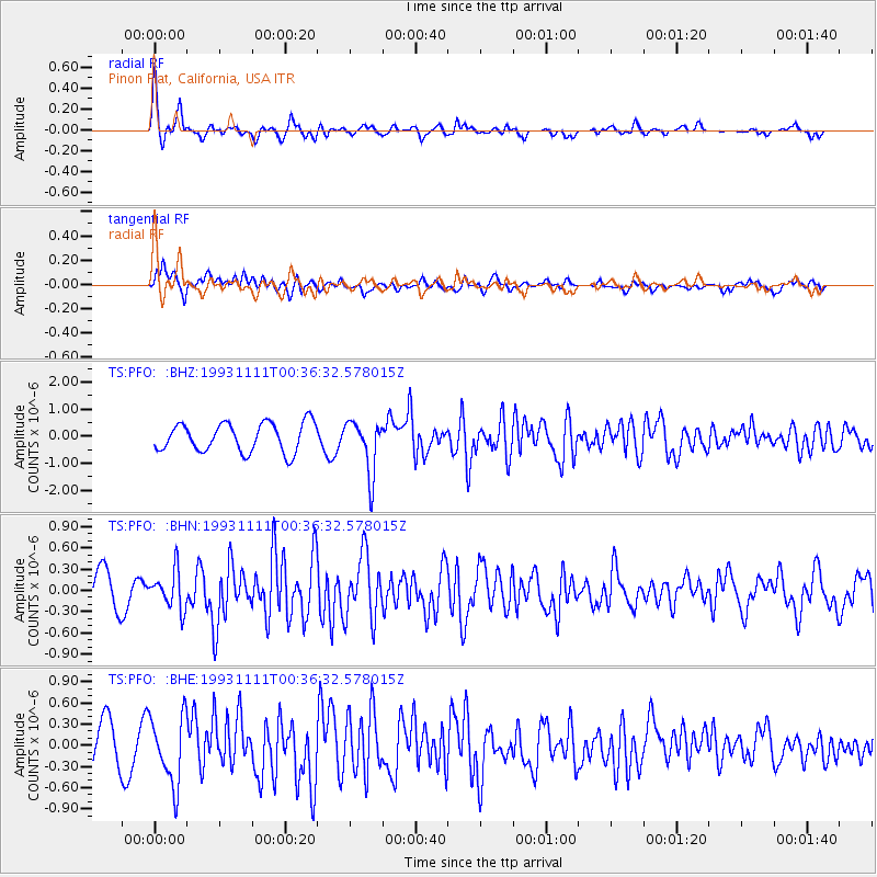
Earthquake location: Andreanof Islands, Aleutian Is.
Earthquake latitude/longitude: 50.2/-177.4
Earthquake time(UTC): 1993/11/11 (315) 00:28:34 GMT
Earthquake Depth: 23 km
Earthquake Magnitude: 6.3 MB, 5.7 MS, 6.0 UNKNOWN, 5.9 ML
Earthquake Catalog/Contributor: WHDF/NEIC
Network: TS TERRAscope (Southern California Seismic Network)
Station: PFO Pinon Flat, California, USA
Lat/Lon: 33.61 N/116.46 W
Elevation: 1280 m
Distance: 47.0 deg
Az: 86.584 deg
Baz: 309.799 deg
Ray Param: 0.07026302
Estimated Moho Depth: 26.5 km
Estimated Crust Vp/Vs: 1.89
Assumed Crust Vp: 6.264 km/s
Estimated Crust Vs: 3.314 km/s
Estimated Crust Poisson's Ratio: 0.31
Radial Match: 88.78175 %
Radial Bump: 400
Transverse Match: 78.20326 %
Transverse Bump: 400
SOD ConfigId: 16938
Insert Time: 2010-02-26 14:42:29.694 +0000
GWidth: 2.5
Max Bumps: 400
Tol: 0.001

Signal To Noise

ChannelStoNSTALTA
TS:PFO: :BHN:19931111T00:36:32.578015Z1.05607262.6509767E-72.5102221E-7
TS:PFO: :BHE:19931111T00:36:32.578015Z1.67579484.795844E-72.8618322E-7
TS:PFO: :BHZ:19931111T00:36:32.578015Z1.82900139.714448E-75.31134E-7
Arrivals
Ps4.0 SECOND
PpPs12 SECOND
PsPs/PpSs16 SECOND