You are here: Home > Network List > MN - MEDNET Project Stations List
> Station VTS Vitosha, Bulgary > Earthquake Result Viewer
VTS Vitosha, Bulgary - Earthquake Result Viewer
| Earthquake location: |
Kyushu, Japan |
| Earthquake latitude/longitude: |
30.6/131.1 |
| Earthquake time(UTC): |
1999/01/24 (024) 00:37:04 GMT |
| Earthquake Depth: |
33 km |
| Earthquake Magnitude: |
6.1 MB, 6.1 MS, 6.4 MW, 6.4 MW |
| Earthquake Catalog/Contributor: |
WHDF/NEIC |
|
| Network: |
MN MEDNET Project |
| Station: |
VTS Vitosha, Bulgary |
| Lat/Lon: |
42.62 N/23.24 E |
| Elevation: |
1490 m |
|
| Distance: |
81.6 deg |
| Az: |
314.74 deg |
| Baz: |
56.054 deg |
| Ray Param: |
0.04745813 |
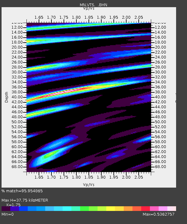
| Estimated Moho Depth: |
37.75 km |
| Estimated Crust Vp/Vs: |
1.75 |
| Assumed Crust Vp: |
6.291 km/s |
| Estimated Crust Vs: |
3.595 km/s |
| Estimated Crust Poisson's Ratio: |
0.26 |
|
| Radial Match: |
95.954865 % |
| Radial Bump: |
400 |
| Transverse Match: |
88.57232 % |
| Transverse Bump: |
400 |
| SOD ConfigId: |
4480 |
| Insert Time: |
2010-03-08 17:51:01.157 +0000 |
| GWidth: |
2.5 |
| Max Bumps: |
400 |
| Tol: |
0.001 |
|

Signal To Noise
| Channel | StoN | STA | LTA |
| MN:VTS: :BHN:19990124T00:48:47.848994Z | 17.099466 | 1.1035163E-6 | 6.453513E-8 |
| MN:VTS: :BHE:19990124T00:48:47.848994Z | 6.22455 | 2.4722553E-7 | 3.971782E-8 |
| MN:VTS: :BHZ:19990124T00:48:47.848018Z | 8.237407 | 2.681221E-7 | 3.2549337E-8 |
| Arrivals |
| Ps | 4.6 SECOND |
| PpPs | 16 SECOND |
| PsPs/PpSs | 21 SECOND |


