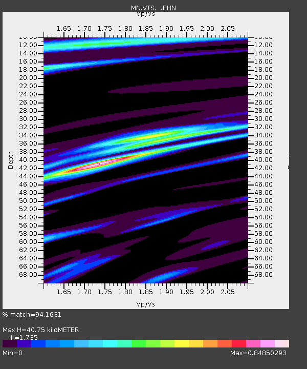
VTS Vitosha, Bulgary - Earthquake Result Viewer

Earthquake location: Fox Islands, Aleutian Islands
Earthquake latitude/longitude: 52.9/-169.1
Earthquake time(UTC): 1999/01/28 (028) 08:10:05 GMT
Earthquake Depth: 67 km
Earthquake Magnitude: 6.3 MB, 6.1 MS, 6.6 MW, 6.6 ME
Earthquake Catalog/Contributor: WHDF/NEIC
Network: MN MEDNET Project
Station: VTS Vitosha, Bulgary
Lat/Lon: 42.62 N/23.24 E
Elevation: 1490 m
Distance: 84.3 deg
Az: 350.865 deg
Baz: 7.489 deg
Ray Param: 0.04546799
Estimated Moho Depth: 40.75 km
Estimated Crust Vp/Vs: 1.74
Assumed Crust Vp: 6.291 km/s
Estimated Crust Vs: 3.626 km/s
Estimated Crust Poisson's Ratio: 0.25
Radial Match: 94.1631 %
Radial Bump: 400
Transverse Match: 78.14745 %
Transverse Bump: 400
SOD ConfigId: 4480
Insert Time: 2010-03-08 17:51:05.662 +0000
GWidth: 2.5
Max Bumps: 400
Tol: 0.001

Signal To Noise

ChannelStoNSTALTA
MN:VTS: :BHN:19990128T08:21:58.737993Z14.3232371.0536112E-67.355957E-8
MN:VTS: :BHE:19990128T08:21:58.740007Z5.1659783.6836943E-77.1306815E-8
MN:VTS: :BHZ:19990128T08:21:58.737993Z1.24454751.2520042E-71.0059915E-7
Arrivals
Ps4.9 SECOND
PpPs17 SECOND
PsPs/PpSs22 SECOND