You are here: Home > Network List > MN - MEDNET Project Stations List
> Station VTS Vitosha, Bulgary > Earthquake Result Viewer
VTS Vitosha, Bulgary - Earthquake Result Viewer
| Earthquake location: |
Taiwan Region |
| Earthquake latitude/longitude: |
24.1/122.2 |
| Earthquake time(UTC): |
2009/07/13 (194) 18:05:01 GMT |
| Earthquake Depth: |
17 km |
| Earthquake Magnitude: |
6.1 MB, 6.3 MS, 6.3 MW, 6.2 MW |
| Earthquake Catalog/Contributor: |
WHDF/NEIC |
|
| Network: |
MN MEDNET Project |
| Station: |
VTS Vitosha, Bulgary |
| Lat/Lon: |
42.62 N/23.24 E |
| Elevation: |
1490 m |
|
| Distance: |
80.3 deg |
| Az: |
312.296 deg |
| Baz: |
66.356 deg |
| Ray Param: |
0.04835067 |
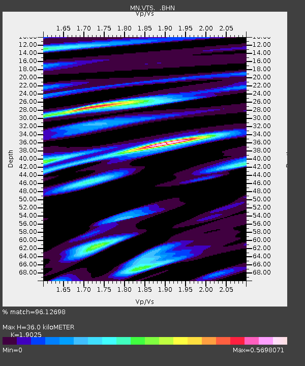
| Estimated Moho Depth: |
36.0 km |
| Estimated Crust Vp/Vs: |
1.90 |
| Assumed Crust Vp: |
6.291 km/s |
| Estimated Crust Vs: |
3.307 km/s |
| Estimated Crust Poisson's Ratio: |
0.31 |
|
| Radial Match: |
96.12698 % |
| Radial Bump: |
370 |
| Transverse Match: |
90.70328 % |
| Transverse Bump: |
400 |
| SOD ConfigId: |
2648 |
| Insert Time: |
2010-03-08 17:51:06.695 +0000 |
| GWidth: |
2.5 |
| Max Bumps: |
400 |
| Tol: |
0.001 |
|

Signal To Noise
| Channel | StoN | STA | LTA |
| MN:VTS: :BHN:20090713T18:16:40.029009Z | 78.648056 | 1.8670318E-6 | 2.373907E-8 |
| MN:VTS: :BHE:20090713T18:16:40.029009Z | 5.3780165 | 2.3662581E-7 | 4.399871E-8 |
| MN:VTS: :BHZ:20090713T18:16:40.029009Z | 5.6505423 | 4.2987585E-7 | 7.607692E-8 |
| Arrivals |
| Ps | 5.3 SECOND |
| PpPs | 16 SECOND |
| PsPs/PpSs | 21 SECOND |


