You are here: Home > Network List > AV - Alaska Volcano Observatory Stations List
> Station SPCR Ckakachatna River, Mount Spurr, Alaska > Earthquake Result Viewer
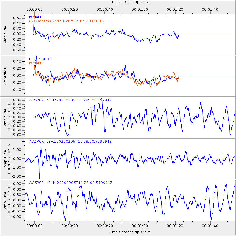
SPCR Ckakachatna River, Mount Spurr, Alaska - Earthquake Result Viewer
*The percent match for this event was below the threshold and hence no stack was calculated.
| Earthquake location: |
Near East Coast Of Honshu, Japan |
| Earthquake latitude/longitude: |
36.4/141.8 |
| Earthquake time(UTC): |
2020/02/06 (037) 11:19:56 GMT |
| Earthquake Depth: |
10 km |
| Earthquake Magnitude: |
5.3 Mww |
| Earthquake Catalog/Contributor: |
NEIC PDE/us |
|
| Network: |
AV Alaska Volcano Observatory |
| Station: |
SPCR Ckakachatna River, Mount Spurr, Alaska |
| Lat/Lon: |
61.20 N/152.21 W |
| Elevation: |
984 m |
|
| Distance: |
47.5 deg |
| Az: |
36.866 deg |
| Baz: |
269.851 deg |
| Ray Param: |
$rayparam |
*The percent match for this event was below the threshold and hence was not used in the summary stack. |
|
| Radial Match: |
52.229935 % |
| Radial Bump: |
400 |
| Transverse Match: |
52.279686 % |
| Transverse Bump: |
400 |
| SOD ConfigId: |
20465011 |
| Insert Time: |
2020-02-23 07:06:23.536 +0000 |
| GWidth: |
2.5 |
| Max Bumps: |
400 |
| Tol: |
0.001 |
|
Signal To Noise
| Channel | StoN | STA | LTA |
| AV:SPCR: :BHZ:20200206T11:28:00.559991Z | 4.4531126 | 7.5799875E-7 | 1.7021775E-7 |
| AV:SPCR: :BHN:20200206T11:28:00.559991Z | 1.353421 | 4.301118E-7 | 3.1779604E-7 |
| AV:SPCR: :BHE:20200206T11:28:00.559991Z | 1.3970149 | 4.2317265E-7 | 3.0291207E-7 |
| Arrivals |
| Ps | |
| PpPs | |
| PsPs/PpSs | |


