You are here: Home > Network List > CN - Canadian National Seismograph Network Stations List
> Station INK INUVIK, NT > Earthquake Result Viewer
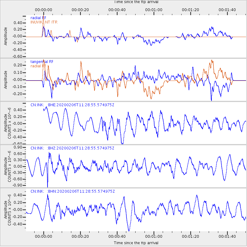
INK INUVIK, NT - Earthquake Result Viewer
*The percent match for this event was below the threshold and hence no stack was calculated.
| Earthquake location: |
Near East Coast Of Honshu, Japan |
| Earthquake latitude/longitude: |
36.4/141.8 |
| Earthquake time(UTC): |
2020/02/06 (037) 11:19:56 GMT |
| Earthquake Depth: |
10 km |
| Earthquake Magnitude: |
5.3 Mww |
| Earthquake Catalog/Contributor: |
NEIC PDE/us |
|
| Network: |
CN Canadian National Seismograph Network |
| Station: |
INK INUVIK, NT |
| Lat/Lon: |
68.31 N/133.53 W |
| Elevation: |
44 m |
|
| Distance: |
54.8 deg |
| Az: |
26.928 deg |
| Baz: |
280.533 deg |
| Ray Param: |
$rayparam |
*The percent match for this event was below the threshold and hence was not used in the summary stack. |
|
| Radial Match: |
62.31407 % |
| Radial Bump: |
400 |
| Transverse Match: |
55.87409 % |
| Transverse Bump: |
400 |
| SOD ConfigId: |
20465011 |
| Insert Time: |
2020-02-23 08:08:07.373 +0000 |
| GWidth: |
2.5 |
| Max Bumps: |
400 |
| Tol: |
0.001 |
|
Signal To Noise
| Channel | StoN | STA | LTA |
| CN:INK: :BHZ:20200206T11:28:55.574975Z | 2.081387 | 3.939406E-7 | 1.892683E-7 |
| CN:INK: :BHN:20200206T11:28:55.574975Z | 1.7126392 | 2.5693114E-7 | 1.5002058E-7 |
| CN:INK: :BHE:20200206T11:28:55.574975Z | 1.1881247 | 2.685753E-7 | 2.2604976E-7 |
| Arrivals |
| Ps | |
| PpPs | |
| PsPs/PpSs | |


