You are here: Home > Network List > TS - TERRAscope (Southern California Seismic Network) Stations List
> Station PFO Pinon Flat, California, USA > Earthquake Result Viewer
PFO Pinon Flat, California, USA - Earthquake Result Viewer

| Earthquake location: |
Western Brazil |
| Earthquake latitude/longitude: |
-8.5/-71.5 |
| Earthquake time(UTC): |
1993/05/06 (126) 13:03:19 GMT |
| Earthquake Depth: |
586 km |
| Earthquake Magnitude: |
5.8 MB, 5.8 UNKNOWN |
| Earthquake Catalog/Contributor: |
WHDF/NEIC |
|
| Network: |
TS TERRAscope (Southern California Seismic Network) |
| Station: |
PFO Pinon Flat, California, USA |
| Lat/Lon: |
33.61 N/116.46 W |
| Elevation: |
1280 m |
|
| Distance: |
59.8 deg |
| Az: |
316.954 deg |
| Baz: |
125.991 deg |
| Ray Param: |
0.059621777 |
| Estimated Moho Depth: |
68.0 km |
| Estimated Crust Vp/Vs: |
1.93 |
| Assumed Crust Vp: |
6.264 km/s |
| Estimated Crust Vs: |
3.25 km/s |
| Estimated Crust Poisson's Ratio: |
0.32 |
|
| Radial Match: |
82.37824 % |
| Radial Bump: |
355 |
| Transverse Match: |
65.48997 % |
| Transverse Bump: |
393 |
| SOD ConfigId: |
17000 |
| Insert Time: |
2010-02-26 14:42:32.137 +0000 |
| GWidth: |
2.5 |
| Max Bumps: |
400 |
| Tol: |
0.001 |
|
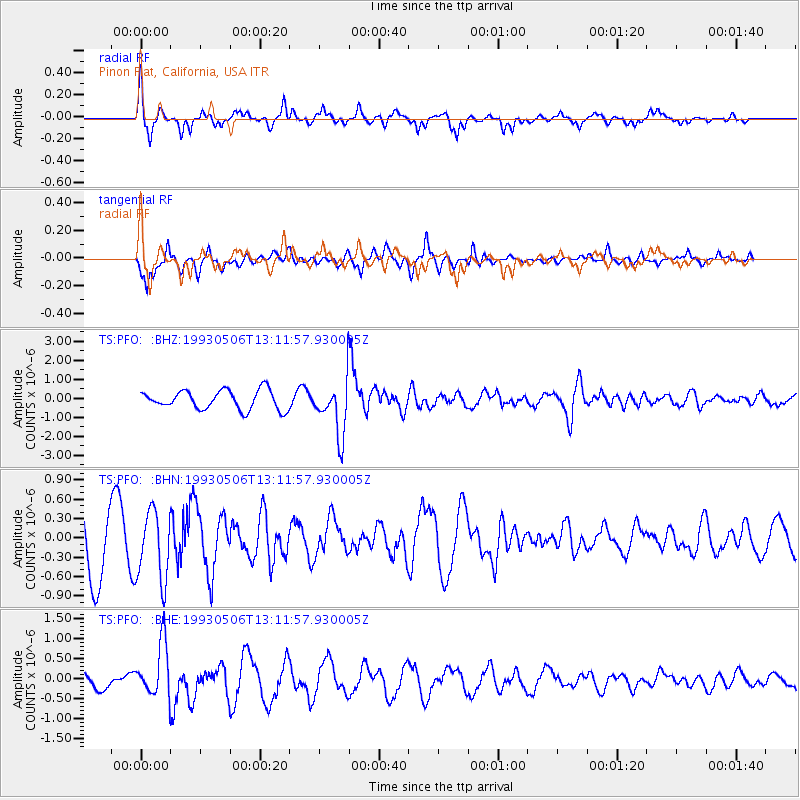
Signal To Noise
| Channel | StoN | STA | LTA |
| TS:PFO: :BHN:19930506T13:11:57.930005Z | 1.2160056 | 5.379542E-7 | 4.4239448E-7 |
| TS:PFO: :BHE:19930506T13:11:57.930005Z | 3.6086586 | 6.80867E-7 | 1.8867593E-7 |
| TS:PFO: :BHZ:19930506T13:11:57.930005Z | 2.9622962 | 1.4839503E-6 | 5.0094593E-7 |
| Arrivals |
| Ps | 10 SECOND |
| PpPs | 31 SECOND |
| PsPs/PpSs | 41 SECOND |


