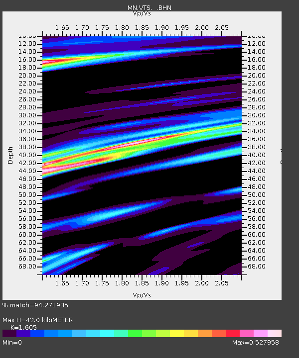
VTS Vitosha, Bulgary - Earthquake Result Viewer

Earthquake location: Andreanof Islands, Aleutian Is.
Earthquake latitude/longitude: 51.2/-179.3
Earthquake time(UTC): 2006/07/08 (189) 20:40:00 GMT
Earthquake Depth: 22 km
Earthquake Magnitude: 6.2 MB, 6.4 MS, 6.6 MW, 6.6 MW
Earthquake Catalog/Contributor: WHDF/NEIC
Network: MN MEDNET Project
Station: VTS Vitosha, Bulgary
Lat/Lon: 42.62 N/23.24 E
Elevation: 1490 m
Distance: 84.5 deg
Az: 343.481 deg
Baz: 14.021 deg
Ray Param: 0.04541093
Estimated Moho Depth: 42.0 km
Estimated Crust Vp/Vs: 1.61
Assumed Crust Vp: 6.291 km/s
Estimated Crust Vs: 3.92 km/s
Estimated Crust Poisson's Ratio: 0.18
Radial Match: 94.271935 %
Radial Bump: 400
Transverse Match: 86.615974 %
Transverse Bump: 400
SOD ConfigId: 2665
Insert Time: 2010-03-08 17:51:35.521 +0000
GWidth: 2.5
Max Bumps: 400
Tol: 0.001

Signal To Noise

ChannelStoNSTALTA
MN:VTS: :BHN:20060708T20:52:00.717Z15.8827564.2763028E-72.6924186E-8
MN:VTS: :BHE:20060708T20:52:00.717Z2.69519971.0918581E-74.0511214E-8
MN:VTS: :BHZ:20060708T20:52:00.717Z28.1923941.2005171E-64.258301E-8
Arrivals
Ps4.1 SECOND
PpPs17 SECOND
PsPs/PpSs21 SECOND