You are here: Home > Network List > TS - TERRAscope (Southern California Seismic Network) Stations List
> Station PFO Pinon Flat, California, USA > Earthquake Result Viewer
PFO Pinon Flat, California, USA - Earthquake Result Viewer
| Earthquake location: |
Peru-Bolivia Border Region |
| Earthquake latitude/longitude: |
-13.3/-69.4 |
| Earthquake time(UTC): |
1994/01/10 (010) 15:53:49 GMT |
| Earthquake Depth: |
589 km |
| Earthquake Magnitude: |
6.4 MB, 6.4 UNKNOWN, 6.9 MW |
| Earthquake Catalog/Contributor: |
WHDF/NEIC |
|
| Network: |
TS TERRAscope (Southern California Seismic Network) |
| Station: |
PFO Pinon Flat, California, USA |
| Lat/Lon: |
33.61 N/116.46 W |
| Elevation: |
1280 m |
|
| Distance: |
64.7 deg |
| Az: |
317.481 deg |
| Baz: |
127.968 deg |
| Ray Param: |
0.056548886 |
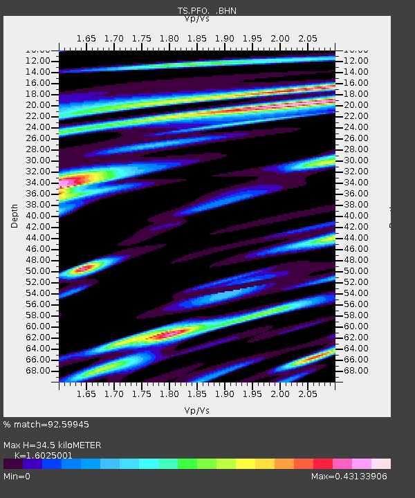
| Estimated Moho Depth: |
34.5 km |
| Estimated Crust Vp/Vs: |
1.60 |
| Assumed Crust Vp: |
6.264 km/s |
| Estimated Crust Vs: |
3.909 km/s |
| Estimated Crust Poisson's Ratio: |
0.18 |
|
| Radial Match: |
92.59945 % |
| Radial Bump: |
400 |
| Transverse Match: |
81.795204 % |
| Transverse Bump: |
400 |
| SOD ConfigId: |
16938 |
| Insert Time: |
2010-02-26 14:42:33.296 +0000 |
| GWidth: |
2.5 |
| Max Bumps: |
400 |
| Tol: |
0.001 |
|
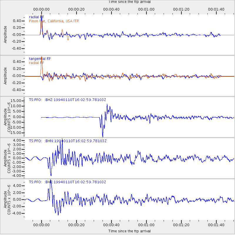
Signal To Noise
| Channel | StoN | STA | LTA |
| TS:PFO: :BHN:19940110T16:02:59.78103Z | 3.96007 | 6.573428E-7 | 1.6599273E-7 |
| TS:PFO: :BHE:19940110T16:02:59.78103Z | 5.211316 | 1.1090641E-6 | 2.1281843E-7 |
| TS:PFO: :BHZ:19940110T16:02:59.78103Z | 18.85786 | 3.352157E-6 | 1.7775913E-7 |
| Arrivals |
| Ps | 3.5 SECOND |
| PpPs | 14 SECOND |
| PsPs/PpSs | 17 SECOND |


