You are here: Home > Network List > TA - USArray Transportable Network (new EarthScope stations) Stations List
> Station E18K Tukpahlearik Creek, AK, USA > Earthquake Result Viewer
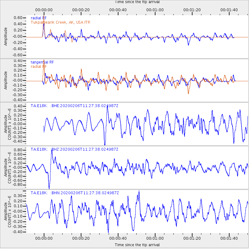
E18K Tukpahlearik Creek, AK, USA - Earthquake Result Viewer
*The percent match for this event was below the threshold and hence no stack was calculated.
| Earthquake location: |
Near East Coast Of Honshu, Japan |
| Earthquake latitude/longitude: |
36.4/141.8 |
| Earthquake time(UTC): |
2020/02/06 (037) 11:19:56 GMT |
| Earthquake Depth: |
10 km |
| Earthquake Magnitude: |
5.3 Mww |
| Earthquake Catalog/Contributor: |
NEIC PDE/us |
|
| Network: |
TA USArray Transportable Network (new EarthScope stations) |
| Station: |
E18K Tukpahlearik Creek, AK, USA |
| Lat/Lon: |
67.42 N/160.60 W |
| Elevation: |
297 m |
|
| Distance: |
44.6 deg |
| Az: |
27.643 deg |
| Baz: |
255.872 deg |
| Ray Param: |
$rayparam |
*The percent match for this event was below the threshold and hence was not used in the summary stack. |
|
| Radial Match: |
65.25744 % |
| Radial Bump: |
400 |
| Transverse Match: |
47.087738 % |
| Transverse Bump: |
400 |
| SOD ConfigId: |
20465011 |
| Insert Time: |
2020-02-23 10:30:17.939 +0000 |
| GWidth: |
2.5 |
| Max Bumps: |
400 |
| Tol: |
0.001 |
|
Signal To Noise
| Channel | StoN | STA | LTA |
| TA:E18K: :BHZ:20200206T11:27:38.024987Z | 3.995482 | 4.422118E-7 | 1.10677966E-7 |
| TA:E18K: :BHN:20200206T11:27:38.024987Z | 1.133094 | 9.359833E-8 | 8.260421E-8 |
| TA:E18K: :BHE:20200206T11:27:38.024987Z | 2.0374284 | 2.2111787E-7 | 1.0852792E-7 |
| Arrivals |
| Ps | |
| PpPs | |
| PsPs/PpSs | |


