You are here: Home > Network List > TS - TERRAscope (Southern California Seismic Network) Stations List
> Station PFO Pinon Flat, California, USA > Earthquake Result Viewer
PFO Pinon Flat, California, USA - Earthquake Result Viewer
| Earthquake location: |
Vanuatu Islands |
| Earthquake latitude/longitude: |
-18.8/169.2 |
| Earthquake time(UTC): |
1994/02/11 (042) 21:17:31 GMT |
| Earthquake Depth: |
204 km |
| Earthquake Magnitude: |
6.3 MB, 7.0 UNKNOWN, 6.8 MW |
| Earthquake Catalog/Contributor: |
WHDF/NEIC |
|
| Network: |
TS TERRAscope (Southern California Seismic Network) |
| Station: |
PFO Pinon Flat, California, USA |
| Lat/Lon: |
33.61 N/116.46 W |
| Elevation: |
1280 m |
|
| Distance: |
87.9 deg |
| Az: |
53.539 deg |
| Baz: |
245.905 deg |
| Ray Param: |
0.042490967 |
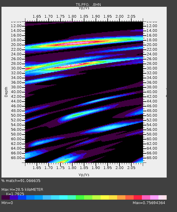
| Estimated Moho Depth: |
28.5 km |
| Estimated Crust Vp/Vs: |
1.79 |
| Assumed Crust Vp: |
6.264 km/s |
| Estimated Crust Vs: |
3.494 km/s |
| Estimated Crust Poisson's Ratio: |
0.27 |
|
| Radial Match: |
91.066635 % |
| Radial Bump: |
400 |
| Transverse Match: |
68.071945 % |
| Transverse Bump: |
400 |
| SOD ConfigId: |
16938 |
| Insert Time: |
2010-02-26 14:42:34.431 +0000 |
| GWidth: |
2.5 |
| Max Bumps: |
400 |
| Tol: |
0.001 |
|
Signal To Noise
| Channel | StoN | STA | LTA |
| TS:PFO: :BHN:19940211T21:29:26.749023Z | 4.3332057 | 9.762563E-7 | 2.2529653E-7 |
| TS:PFO: :BHE:19940211T21:29:26.749023Z | 13.171024 | 1.911163E-6 | 1.451036E-7 |
| TS:PFO: :BHZ:19940211T21:29:26.749023Z | 26.754406 | 7.23419E-6 | 2.7039246E-7 |
| Arrivals |
| Ps | 3.7 SECOND |
| PpPs | 12 SECOND |
| PsPs/PpSs | 16 SECOND |


