You are here: Home > Network List > TA - USArray Transportable Network (new EarthScope stations) Stations List
> Station G23K Bananza Creek, AK, USA > Earthquake Result Viewer
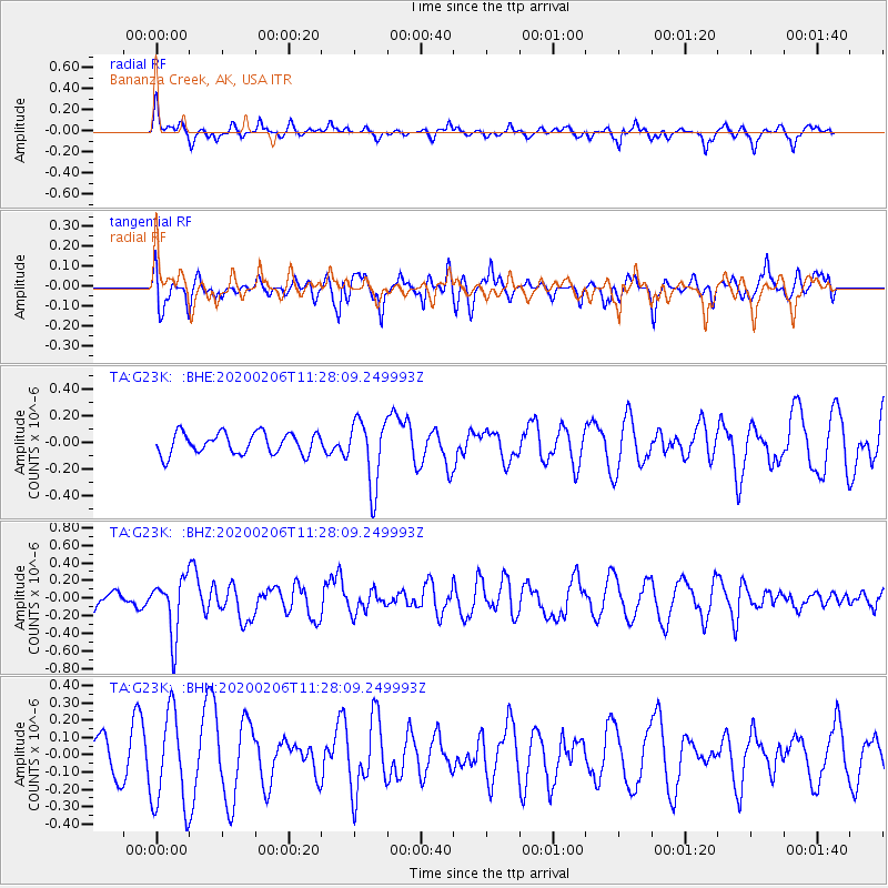
G23K Bananza Creek, AK, USA - Earthquake Result Viewer
*The percent match for this event was below the threshold and hence no stack was calculated.
| Earthquake location: |
Near East Coast Of Honshu, Japan |
| Earthquake latitude/longitude: |
36.4/141.8 |
| Earthquake time(UTC): |
2020/02/06 (037) 11:19:56 GMT |
| Earthquake Depth: |
10 km |
| Earthquake Magnitude: |
5.3 Mww |
| Earthquake Catalog/Contributor: |
NEIC PDE/us |
|
| Network: |
TA USArray Transportable Network (new EarthScope stations) |
| Station: |
G23K Bananza Creek, AK, USA |
| Lat/Lon: |
66.71 N/150.02 W |
| Elevation: |
746 m |
|
| Distance: |
48.6 deg |
| Az: |
29.465 deg |
| Baz: |
266.862 deg |
| Ray Param: |
$rayparam |
*The percent match for this event was below the threshold and hence was not used in the summary stack. |
|
| Radial Match: |
57.748135 % |
| Radial Bump: |
395 |
| Transverse Match: |
47.738873 % |
| Transverse Bump: |
400 |
| SOD ConfigId: |
20465011 |
| Insert Time: |
2020-02-23 10:33:19.682 +0000 |
| GWidth: |
2.5 |
| Max Bumps: |
400 |
| Tol: |
0.001 |
|
Signal To Noise
| Channel | StoN | STA | LTA |
| TA:G23K: :BHZ:20200206T11:28:09.249993Z | 1.6601261 | 3.1906887E-7 | 1.9219556E-7 |
| TA:G23K: :BHN:20200206T11:28:09.249993Z | 2.481613 | 2.744852E-7 | 1.1060757E-7 |
| TA:G23K: :BHE:20200206T11:28:09.249993Z | 3.1527982 | 2.497461E-7 | 7.921411E-8 |
| Arrivals |
| Ps | |
| PpPs | |
| PsPs/PpSs | |


