You are here: Home > Network List > TA - USArray Transportable Network (new EarthScope stations) Stations List
> Station H31M Peel River, Yukon, CAN > Earthquake Result Viewer
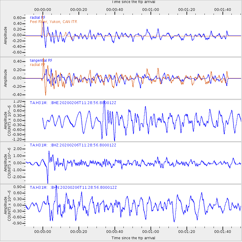
H31M Peel River, Yukon, CAN - Earthquake Result Viewer
*The percent match for this event was below the threshold and hence no stack was calculated.
| Earthquake location: |
Near East Coast Of Honshu, Japan |
| Earthquake latitude/longitude: |
36.4/141.8 |
| Earthquake time(UTC): |
2020/02/06 (037) 11:19:56 GMT |
| Earthquake Depth: |
10 km |
| Earthquake Magnitude: |
5.3 Mww |
| Earthquake Catalog/Contributor: |
NEIC PDE/us |
|
| Network: |
TA USArray Transportable Network (new EarthScope stations) |
| Station: |
H31M Peel River, Yukon, CAN |
| Lat/Lon: |
65.81 N/134.34 W |
| Elevation: |
642 m |
|
| Distance: |
55.0 deg |
| Az: |
30.017 deg |
| Baz: |
281.557 deg |
| Ray Param: |
$rayparam |
*The percent match for this event was below the threshold and hence was not used in the summary stack. |
|
| Radial Match: |
69.43499 % |
| Radial Bump: |
400 |
| Transverse Match: |
53.53548 % |
| Transverse Bump: |
369 |
| SOD ConfigId: |
20465011 |
| Insert Time: |
2020-02-23 10:34:37.216 +0000 |
| GWidth: |
2.5 |
| Max Bumps: |
400 |
| Tol: |
0.001 |
|
Signal To Noise
| Channel | StoN | STA | LTA |
| TA:H31M: :BHZ:20200206T11:28:56.800012Z | 4.126588 | 9.577803E-7 | 2.3209984E-7 |
| TA:H31M: :BHN:20200206T11:28:56.800012Z | 1.6577933 | 2.8013886E-7 | 1.68983E-7 |
| TA:H31M: :BHE:20200206T11:28:56.800012Z | 1.8612082 | 5.793205E-7 | 3.1126046E-7 |
| Arrivals |
| Ps | |
| PpPs | |
| PsPs/PpSs | |


