You are here: Home > Network List > US - United States National Seismic Network Stations List
> Station WUAZ Wupatki, Arizona, USA > Earthquake Result Viewer
WUAZ Wupatki, Arizona, USA - Earthquake Result Viewer
*The percent match for this event was below the threshold and hence no stack was calculated.
| Earthquake location: |
Near East Coast Of Honshu, Japan |
| Earthquake latitude/longitude: |
36.4/141.8 |
| Earthquake time(UTC): |
2020/02/06 (037) 11:19:56 GMT |
| Earthquake Depth: |
10 km |
| Earthquake Magnitude: |
5.3 Mww |
| Earthquake Catalog/Contributor: |
NEIC PDE/us |
|
| Network: |
US United States National Seismic Network |
| Station: |
WUAZ Wupatki, Arizona, USA |
| Lat/Lon: |
35.52 N/111.37 W |
| Elevation: |
1592 m |
|
| Distance: |
81.3 deg |
| Az: |
52.197 deg |
| Baz: |
308.579 deg |
| Ray Param: |
$rayparam |
*The percent match for this event was below the threshold and hence was not used in the summary stack. |
|
| Radial Match: |
74.94829 % |
| Radial Bump: |
400 |
| Transverse Match: |
58.74655 % |
| Transverse Bump: |
400 |
| SOD ConfigId: |
20465011 |
| Insert Time: |
2020-02-23 10:59:31.700 +0000 |
| GWidth: |
2.5 |
| Max Bumps: |
400 |
| Tol: |
0.001 |
|
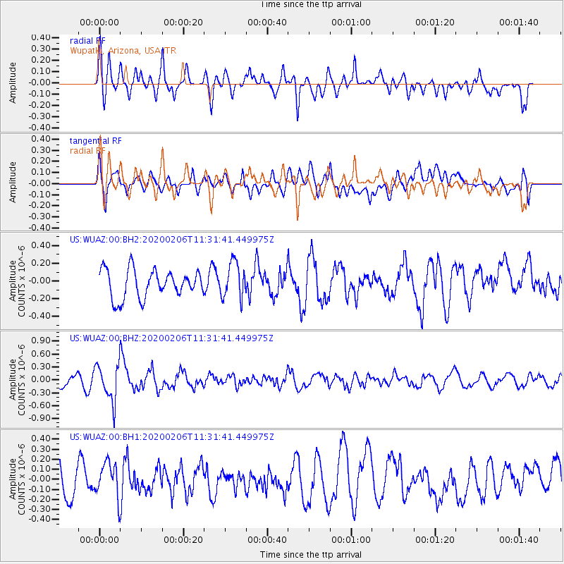
Signal To Noise
| Channel | StoN | STA | LTA |
| US:WUAZ:00:BHZ:20200206T11:31:41.449975Z | 1.9889034 | 4.3934642E-7 | 2.2089883E-7 |
| US:WUAZ:00:BH1:20200206T11:31:41.449975Z | 1.0662198 | 1.8393389E-7 | 1.7251028E-7 |
| US:WUAZ:00:BH2:20200206T11:31:41.449975Z | 1.3161988 | 2.0760787E-7 | 1.5773291E-7 |
| Arrivals |
| Ps | |
| PpPs | |
| PsPs/PpSs | |


