You are here: Home > Network List > MM - Myanmar National Seismic Network Stations List
> Station TMU Tamu, Sagaing, Myanmar > Earthquake Result Viewer
TMU Tamu, Sagaing, Myanmar - Earthquake Result Viewer
| Earthquake location: |
Java, Indonesia |
| Earthquake latitude/longitude: |
-6.1/113.1 |
| Earthquake time(UTC): |
2020/02/05 (036) 18:12:37 GMT |
| Earthquake Depth: |
592 km |
| Earthquake Magnitude: |
6.2 mww |
| Earthquake Catalog/Contributor: |
NEIC PDE/us |
|
| Network: |
MM Myanmar National Seismic Network |
| Station: |
TMU Tamu, Sagaing, Myanmar |
| Lat/Lon: |
24.23 N/94.30 E |
| Elevation: |
182 m |
|
| Distance: |
35.3 deg |
| Az: |
329.339 deg |
| Baz: |
146.255 deg |
| Ray Param: |
0.0743032 |
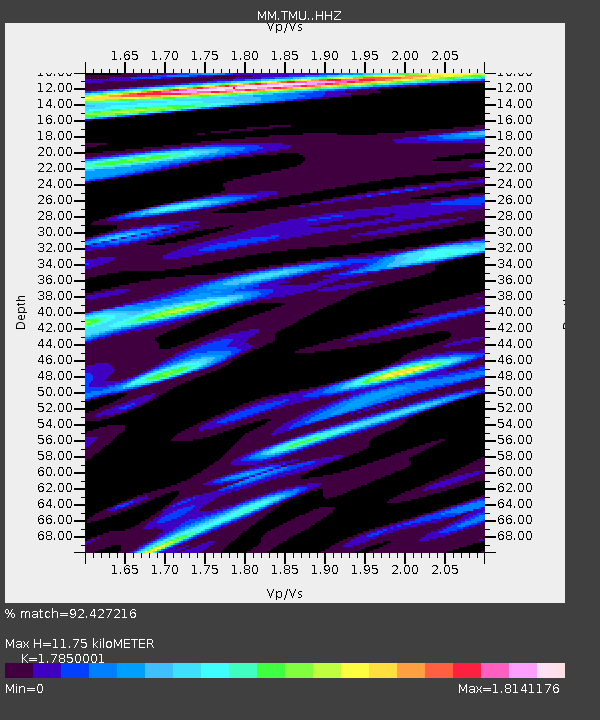
| Estimated Moho Depth: |
11.75 km |
| Estimated Crust Vp/Vs: |
1.79 |
| Assumed Crust Vp: |
6.316 km/s |
| Estimated Crust Vs: |
3.538 km/s |
| Estimated Crust Poisson's Ratio: |
0.27 |
|
| Radial Match: |
92.427216 % |
| Radial Bump: |
400 |
| Transverse Match: |
78.52155 % |
| Transverse Bump: |
400 |
| SOD ConfigId: |
20465011 |
| Insert Time: |
2020-02-24 02:04:56.332 +0000 |
| GWidth: |
2.5 |
| Max Bumps: |
400 |
| Tol: |
0.001 |
|

Signal To Noise
| Channel | StoN | STA | LTA |
| MM:TMU: :HHZ:20200205T18:18:13.577987Z | 675.452 | 3.48739E-5 | 5.1630465E-8 |
| MM:TMU: :HHN:20200205T18:18:13.577987Z | 106.82296 | 3.4000455E-5 | 3.1828793E-7 |
| MM:TMU: :HHE:20200205T18:18:13.577987Z | 433.43542 | 3.6894067E-5 | 8.51201E-8 |
| Arrivals |
| Ps | 1.6 SECOND |
| PpPs | 4.8 SECOND |
| PsPs/PpSs | 6.4 SECOND |


