You are here: Home > Network List > TS - TERRAscope (Southern California Seismic Network) Stations List
> Station PFO Pinon Flat, California, USA > Earthquake Result Viewer
PFO Pinon Flat, California, USA - Earthquake Result Viewer
| Earthquake location: |
Fiji Islands Region |
| Earthquake latitude/longitude: |
-22.0/-179.6 |
| Earthquake time(UTC): |
1994/03/31 (090) 22:40:53 GMT |
| Earthquake Depth: |
591 km |
| Earthquake Magnitude: |
5.9 MB, 6.5 UNKNOWN, 6.5 MW |
| Earthquake Catalog/Contributor: |
WHDF/NEIC |
|
| Network: |
TS TERRAscope (Southern California Seismic Network) |
| Station: |
PFO Pinon Flat, California, USA |
| Lat/Lon: |
33.61 N/116.46 W |
| Elevation: |
1280 m |
|
| Distance: |
81.6 deg |
| Az: |
48.8 deg |
| Baz: |
236.826 deg |
| Ray Param: |
0.0456587 |
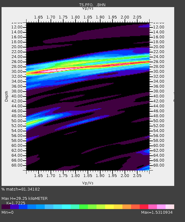
| Estimated Moho Depth: |
29.25 km |
| Estimated Crust Vp/Vs: |
1.72 |
| Assumed Crust Vp: |
6.264 km/s |
| Estimated Crust Vs: |
3.636 km/s |
| Estimated Crust Poisson's Ratio: |
0.25 |
|
| Radial Match: |
81.34182 % |
| Radial Bump: |
322 |
| Transverse Match: |
57.218674 % |
| Transverse Bump: |
304 |
| SOD ConfigId: |
16938 |
| Insert Time: |
2010-02-26 14:42:37.036 +0000 |
| GWidth: |
2.5 |
| Max Bumps: |
400 |
| Tol: |
0.001 |
|
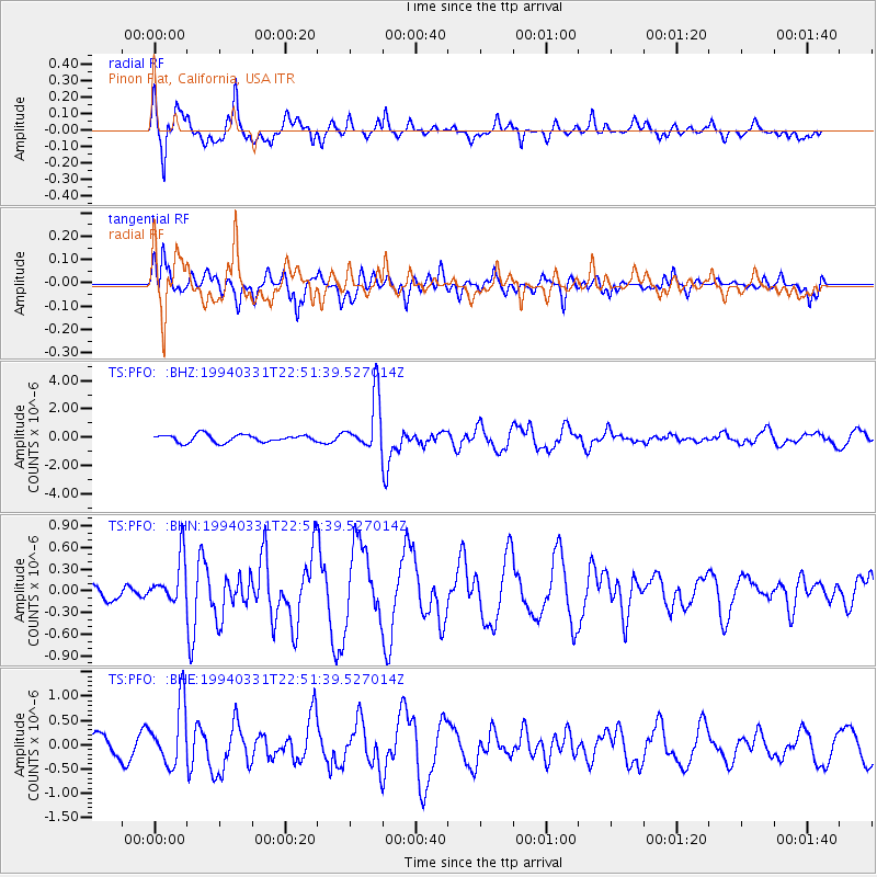
Signal To Noise
| Channel | StoN | STA | LTA |
| TS:PFO: :BHN:19940331T22:51:39.527014Z | 1.3988379 | 3.1890005E-7 | 2.27975E-7 |
| TS:PFO: :BHE:19940331T22:51:39.527014Z | 2.4791737 | 6.301285E-7 | 2.5416875E-7 |
| TS:PFO: :BHZ:19940331T22:51:39.527014Z | 7.2778497 | 1.9259724E-6 | 2.6463482E-7 |
| Arrivals |
| Ps | 3.5 SECOND |
| PpPs | 12 SECOND |
| PsPs/PpSs | 16 SECOND |


