You are here: Home > Network List > TA - USArray Transportable Network (new EarthScope stations) Stations List
> Station C16K Lisburne Hills, AK, USA > Earthquake Result Viewer
C16K Lisburne Hills, AK, USA - Earthquake Result Viewer
| Earthquake location: |
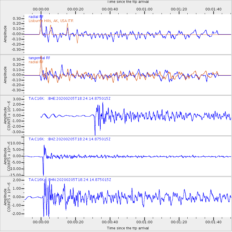
Java, Indonesia |
| Earthquake latitude/longitude: |
-6.1/113.1 |
| Earthquake time(UTC): |
2020/02/05 (036) 18:12:37 GMT |
| Earthquake Depth: |
592 km |
| Earthquake Magnitude: |
6.2 mww |
| Earthquake Catalog/Contributor: |
NEIC PDE/us |
|
| Network: |
TA USArray Transportable Network (new EarthScope stations) |
| Station: |
C16K Lisburne Hills, AK, USA |
| Lat/Lon: |
68.27 N/165.34 W |
| Elevation: |
102 m |
|
| Distance: |
92.5 deg |
| Az: |
21.629 deg |
| Baz: |
259.917 deg |
| Ray Param: |
0.04097741 |
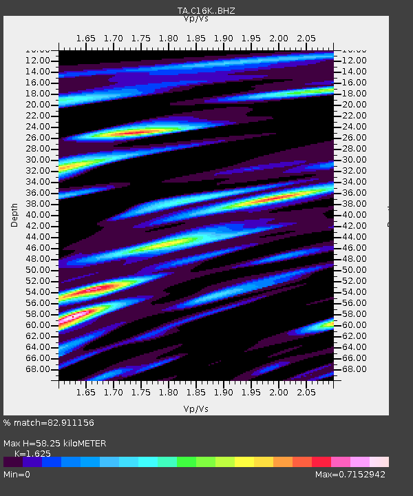
| Estimated Moho Depth: |
58.25 km |
| Estimated Crust Vp/Vs: |
1.62 |
| Assumed Crust Vp: |
5.906 km/s |
| Estimated Crust Vs: |
3.635 km/s |
| Estimated Crust Poisson's Ratio: |
0.20 |
|
| Radial Match: |
82.911156 % |
| Radial Bump: |
400 |
| Transverse Match: |
82.64192 % |
| Transverse Bump: |
400 |
| SOD ConfigId: |
20465011 |
| Insert Time: |
2020-02-24 02:17:54.869 +0000 |
| GWidth: |
2.5 |
| Max Bumps: |
400 |
| Tol: |
0.001 |
|
Signal To Noise
| Channel | StoN | STA | LTA |
| TA:C16K: :BHZ:20200205T18:24:14.875015Z | 22.239906 | 4.1737358E-6 | 1.8766877E-7 |
| TA:C16K: :BHN:20200205T18:24:14.875015Z | 6.558457 | 1.066947E-6 | 1.6268262E-7 |
| TA:C16K: :BHE:20200205T18:24:14.875015Z | 7.767953 | 1.2780226E-6 | 1.6452502E-7 |
| Arrivals |
| Ps | 6.3 SECOND |
| PpPs | 25 SECOND |
| PsPs/PpSs | 32 SECOND |


