You are here: Home > Network List > TA - USArray Transportable Network (new EarthScope stations) Stations List
> Station I17K Unalakleet, AK, USA > Earthquake Result Viewer
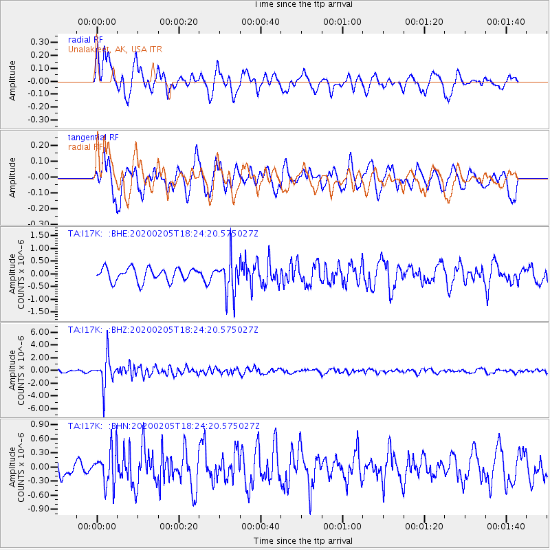
I17K Unalakleet, AK, USA - Earthquake Result Viewer
*The percent match for this event was below the threshold and hence no stack was calculated.
| Earthquake location: |
Java, Indonesia |
| Earthquake latitude/longitude: |
-6.1/113.1 |
| Earthquake time(UTC): |
2020/02/05 (036) 18:12:37 GMT |
| Earthquake Depth: |
592 km |
| Earthquake Magnitude: |
6.2 mww |
| Earthquake Catalog/Contributor: |
NEIC PDE/us |
|
| Network: |
TA USArray Transportable Network (new EarthScope stations) |
| Station: |
I17K Unalakleet, AK, USA |
| Lat/Lon: |
63.89 N/160.70 W |
| Elevation: |
105 m |
|
| Distance: |
93.7 deg |
| Az: |
26.263 deg |
| Baz: |
263.915 deg |
| Ray Param: |
$rayparam |
*The percent match for this event was below the threshold and hence was not used in the summary stack. |
|
| Radial Match: |
67.33494 % |
| Radial Bump: |
400 |
| Transverse Match: |
66.629814 % |
| Transverse Bump: |
400 |
| SOD ConfigId: |
20465011 |
| Insert Time: |
2020-02-24 02:20:12.246 +0000 |
| GWidth: |
2.5 |
| Max Bumps: |
400 |
| Tol: |
0.001 |
|
Signal To Noise
| Channel | StoN | STA | LTA |
| TA:I17K: :BHZ:20200205T18:24:20.575027Z | 11.913811 | 2.4381416E-6 | 2.0464834E-7 |
| TA:I17K: :BHN:20200205T18:24:20.575027Z | 1.5740135 | 3.9678756E-7 | 2.5208652E-7 |
| TA:I17K: :BHE:20200205T18:24:20.575027Z | 2.694676 | 7.0187946E-7 | 2.6046897E-7 |
| Arrivals |
| Ps | |
| PpPs | |
| PsPs/PpSs | |


